IMAGES TAKEN NEAR TO
William Street, GRANTHAM, NG31 6DA
Introduction
This page details the photographs taken nearby to William Street, NG31 6DA by members of the Geograph project.
The Geograph project started in 2005 with the aim of publishing, organising and preserving representative images for every square kilometre of Great Britain, Ireland and the Isle of Man.

There are currently over 7.5m images from over14,400 individuals and you can help contribute to the project by visiting https://www.geograph.org.uk
Image Map
Images are licensed for reuse under creativecommons.org/licenses/by-sa/2.0
Notes
- Clicking on the map will re-center to the selected point.
- The higher the marker number, the further away the image location is from the centre of the postcode.
Image Listing (449 Images Found)
Images are licensed for reuse under creativecommons.org/licenses/by-sa/2.0
Image
Details
Distance
2
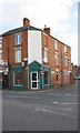
Shop at junction of Wharf Road and Norton Street
The sign on the shop reads 'Circular Systems'. There is an OS benchmark Image on the bricks to the left of the corner door.
Image: © Roger Templeman
Taken: 19 Apr 2014
0.03 miles
3
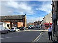
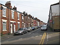
Wharf Road in Grantham
Busy town centre through route. Commercial Road joins the road from the right of picture.
Image: © Jonathan Clitheroe
Taken: 17 Feb 2024
0.03 miles
4
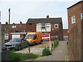
Railway Terrace ends - Grantham, Lincolnshire
View taken at the end of Railway Terrace where it passes the end of Elton Street and comes out onto Norton Street. Time taken 3.12 pm BST (British Summer Time).
Image: © Martin Richard Phelan
Taken: 7 Jun 2016
0.03 miles
5
Norton Street - Grantham, Lincolnshire
View south-east along Norton Street, a one-way street of housing in Grantham, where it joins the pathway leading from Grantham Railway Station to the town centre. Time taken 3.05 pm BST (British Summer Time).
Image: © Martin Richard Phelan
Taken: 7 Jun 2016
0.03 miles
6
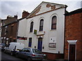
A shocking thing to happen to a church
The Electric Social Club in Commercial Road resides in a former Methodist Church.
Image: © Anthony Vosper
Taken: 15 Feb 2012
0.03 miles
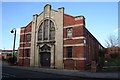
7
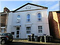
Former chapel, Commercial Road, Grantham
This belonged to the Primitive Methodists and was built in 1837 and enlarged in 1876 https://www.myprimitivemethodists.org.uk/content/chapels/lincolnshire/g-lincolnshire/grantham_commercial_road_primitive_methodist_chapel_lincolnshire Now housing.
Image: © Jonathan Thacker
Taken: 9 Nov 2022
0.03 miles
8
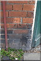
Benchmark on #21 Wharf Road
Ordnance Survey cut mark benchmark described on the Bench Mark Database at http://www.bench-marks.org.uk/bm57241
Image: © Roger Templeman
Taken: 19 Apr 2014
0.03 miles
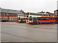
10
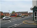
Wharf Road - Grantham, Lincolnshire
View taken at the junction of the northern end of Norton Street and Wharf Road, looking across to Grantham Bus Station. Time taken 3.18 pm BST (British Summer Time).
Image: © Martin Richard Phelan
Taken: 7 Jun 2016
0.04 miles