IMAGES TAKEN NEAR TO
Norton Street, GRANTHAM, NG31 6BX
Introduction
This page details the photographs taken nearby to Norton Street, NG31 6BX by members of the Geograph project.
The Geograph project started in 2005 with the aim of publishing, organising and preserving representative images for every square kilometre of Great Britain, Ireland and the Isle of Man.

There are currently over 7.5m images from over14,400 individuals and you can help contribute to the project by visiting https://www.geograph.org.uk
Image Map
Images are licensed for reuse under creativecommons.org/licenses/by-sa/2.0
Notes
- Clicking on the map will re-center to the selected point.
- The higher the marker number, the further away the image location is from the centre of the postcode.
Image Listing (323 Images Found)
Images are licensed for reuse under creativecommons.org/licenses/by-sa/2.0
Image
Details
Distance
1
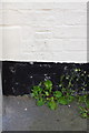
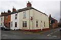
Benchmark on the former Spread Eagle pub, Norton Street
Ordnance Survey cut mark benchmark described on the Bench Mark Database at http://www.bench-marks.org.uk/bm57240
Image: © Roger Templeman
Taken: 19 Apr 2014
0.03 miles
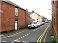
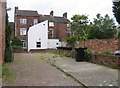
2
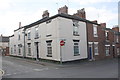
The former Spread Eagle pub, Norton Street/Fletcher Street junction
There is an OS benchmark Image on the near corner of the house, right of the No Entry sign post
Image: © Roger Templeman
Taken: 19 Apr 2014
0.03 miles
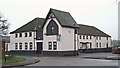
4
The Maltings, Commercial Road, Grantham
Now converted into office premises.
Image: © Alan Murray-Rust
Taken: 15 Feb 2017
0.05 miles
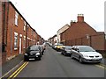
5
Junction of Fletcher Street and Grantley Street
Image: © Roger Templeman
Taken: 7 Apr 2016
0.05 miles
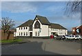
6
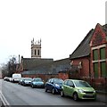
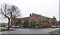
Launder Terrace, Grantham, Lincs.
The northern elevation of the former Spitalgate Church of England Primary School is seen here from near Grantley Street. This section of the former school premises is at the western end of Station Road East, with the town's railway station being no more than 2-3 minutes walk away behind the photographer (as the crow flies). Another taller section of the same building is visible nearer to St John's Church, suggesting perhaps a "Boys' end" and a "Girls' end" in former days. The earliest record of a Church of England school in "Spittlegate" (sic) dates the school's foundation to the early 1840s. However, the school, originally known as Spittlegate National School, was situated on various sites in the Launder Terrace neighbourhood. In October 1940 part of the school was damaged and pupils were moved to various locations throughout the town. Later on the school buildings were occupied by army units during WWII, although in 1948 the girls' and the infants' schools returned to the Launder Terrace premises. The boys' school however, remained at Stonebridge House where it had been relocated during the war. In 1956 the school became a co-educational school and the first boys appeared on the admissions register here on 10 April 1956. The Launder Terrace building was closed on 28th March 1977 and the school was moved to new premises in Trent Road, Earlesfield. These premises now house small retail units and the site is referred to as The Old School Retail Market.
Image: © David Hallam-Jones
Taken: 23 Dec 2017
0.05 miles
7
Commercial Road, Grantham, Lincs.
These former Maltings now house several dental practices and several other service-related enterprises, e.g. a hair salon. To the right of the rubbish skip is where the Church of St John the Evangelist is situated. In addition, behind the photographer, within the former Spitalgate Primary School an indoor market functions.
Image: © David Hallam-Jones
Taken: 23 Dec 2017
0.05 miles
10
Spitalgate, Grantham, Lincs.
The eastern end of the former Spitalgate Church of England Primary School is seen here from Commercial Street. The earliest record of a Church of England school in "Spittlegate" (sic) dates the school's foundation to the early 1840s. However, the school, originally known as Spittlegate National School, was situated on various sites in the Launder Terrace neighbourhood. In October 1940 part of the school was damaged and pupils were moved to various locations throughout the town. Later on the school buildings were occupied by army units during WWII, although in 1948 the girls' and the infants' schools returned to the Launder Terrace premises. The boys' school however, remained at Stonebridge House where it had been relocated during the war. In 1956 the school became a co-educational school and the first boys appeared on the admissions register here on 10 April 1956. The Launder Terrace building was closed in March 1977 and the school was moved to new premises in Trent Road, Earlesfield. These premises now house small retail units and the site is referred to as The Old School Retail Market. The tree seen here is within the grounds of the Anglican Church of St John the Evangelist. The town’s railway station lies 3-4 minutes walk ahead - along Launder Terrace - i.e. to the left of the former school.
Image: © David Hallam-Jones
Taken: 23 Dec 2017
0.06 miles