IMAGES TAKEN NEAR TO
Balmoral Avenue, NOTTINGHAM, NG2 7YH
Introduction
This page details the photographs taken nearby to Balmoral Avenue, NG2 7YH by members of the Geograph project.
The Geograph project started in 2005 with the aim of publishing, organising and preserving representative images for every square kilometre of Great Britain, Ireland and the Isle of Man.

There are currently over 7.5m images from over14,400 individuals and you can help contribute to the project by visiting https://www.geograph.org.uk
Image Map
Images are licensed for reuse under creativecommons.org/licenses/by-sa/2.0
Notes
- Clicking on the map will re-center to the selected point.
- The higher the marker number, the further away the image location is from the centre of the postcode.
Image Listing (418 Images Found)
Images are licensed for reuse under creativecommons.org/licenses/by-sa/2.0
Image
Details
Distance
1
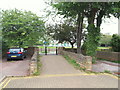
Nottingham - NG2 (W. Bridgford)
The humped footpath connecting Balmoral Avenue with the embankment footpath. This 'bridge' serves as part of local secondary anti-flooding measures. Another example of these arrangements can be seen in neighbouring Sandringham Avenue.
Image: © David Hallam-Jones
Taken: 9 Jun 2012
0.01 miles
2
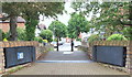
Nottingham - NG2 (W. Bridgford)
A pair of manually-operated metal flood gates and a "humped" footpath connecting the embankment path (behind the photographer) with Balmoral Avenue. This arrangement forms part of secondary anti-flooding measures for this residential area. Examples of these arrangements can also be seen in neighbouring Sandringham Avenue.
Image: © David Hallam-Jones
Taken: 9 Jun 2012
0.01 miles
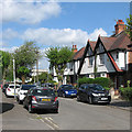
3
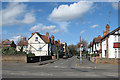
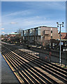
West Bridgford: Balmoral Avenue
A view through a gap in the traffic on Loughborough Road. At the far left-hand end of Balmoral Avenue are the recently-built riverside flats shown in Image
Image: © John Sutton
Taken: 10 Apr 2016
0.01 miles
4
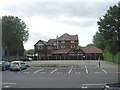
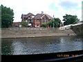
Welbeck Banqueting Hall
The rather unprepossessing rear of the building. The front overlooks the River Trent.
Image: © Alan Murray-Rust
Taken: 23 Sep 2008
0.01 miles
5

A new building next to Welbeck Hall
Welbeck Hall, once a masonic hall, is now a wedding and conference centre. Until quite recently there were two detached houses on this site on the corner of Balmoral Avenue. Evening light on the Bulwell stone wall, red oxide steelwork and Nottingham Patent Brick give the picture an orange flavour.
Image: © John Sutton
Taken: 22 Jun 2014
0.01 miles
6
West Bridgford: new riverside flats
The upper storeys of these recently-built flats are jettied out, so that like many late-mediaeval timber-framed buildings the block is larger than its ground-floor footprint.
For images of the building work, see Image], Image] and Image
Image: © John Sutton
Taken: 10 Apr 2016
0.01 miles
7
Masonic Hall from River Trent West Bridgford
Image: © David Colyer
Taken: 13 Jul 2008
0.02 miles
8
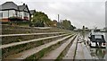
Stepped embankment alongside River Trent near County Hall
Image: © Chris Morgan
Taken: 11 Nov 2013
0.02 miles
9
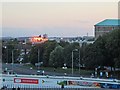
A Bridgford sunset
A view from the Radcliffe Road End of Trent Bridge Cricket Ground, with the setting sun catching the river-facing side of the Rivermead flats on Wilford Lane. The William Clarke Stand is in the foreground, with Loughborough Road beyond and a corner of County Hall on the right. The picture was taken during the day-night One Day Cup quarter final between Nottinghamshire and Derbyshire.
Image: © John Sutton
Taken: 26 Aug 2014
0.02 miles
10
West Bridgford: Balmoral Avenue
Off Loughborough Road. The Nottingham City War Memorial, on Victoria Embankment on the other side of the Trent, shows through the trees.
Image: © John Sutton
Taken: 15 May 2016
0.02 miles