IMAGES TAKEN NEAR TO
Harston Gardens, NOTTINGHAM, NG2 7UY
Introduction
This page details the photographs taken nearby to Harston Gardens, NG2 7UY by members of the Geograph project.
The Geograph project started in 2005 with the aim of publishing, organising and preserving representative images for every square kilometre of Great Britain, Ireland and the Isle of Man.

There are currently over 7.5m images from over14,400 individuals and you can help contribute to the project by visiting https://www.geograph.org.uk
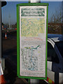
Image Map
Images are licensed for reuse under creativecommons.org/licenses/by-sa/2.0
Notes
- Clicking on the map will re-center to the selected point.
- The higher the marker number, the further away the image location is from the centre of the postcode.
Image Listing (70 Images Found)
Images are licensed for reuse under creativecommons.org/licenses/by-sa/2.0
Image
Details
Distance
1
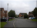
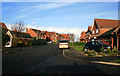
Whatton Drive, West Bridgford
Nestled between Landmere Lane and the A52, just south of Compton Acres estate, this quite upmarket housing development is sufficiently recent not to appear on some scales of OS mapping at the time of posting.
Image: © Richard Vince
Taken: 1 Sep 2012
0.02 miles
2
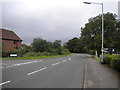
North end of Landmere Lane, West Bridgford
North of the junction with Stonesby Vale (left), Landmere Lane curves west to meet Ruddington Lane.
Image: © Richard Vince
Taken: 1 Sep 2012
0.04 miles
4
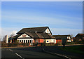
The Apple Tree
Quite modern "estate" pub. Probably 10 to 20 years old, like most of the surrounding houses.
Image: © David Lally
Taken: 22 Jan 2009
0.07 miles
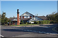
5

The Apple Tree public house
Compton Acres, West Bridgford.
Image: © Ian S
Taken: 31 Aug 2020
0.08 miles
6
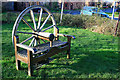
Bench with a coach-wheel back
On Whatton Drive.
Image: © David Lally
Taken: 22 Jan 2009
0.08 miles
7
The Apple Tree public house
Compton Acres, West Bridgford.
Image: © Ian S
Taken: 31 Aug 2020
0.08 miles
8
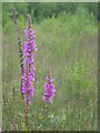
Purple Loosestrife at Wilford claypit
Image: © David Vaughan-Birch
Taken: 8 Aug 2007
0.08 miles
9
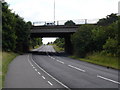
Ruddington Lane
Looking down Ruddington Lane from the southern edge of Wilford. The road carried on the bridge is the A52, and this picture is taken from the opposite side of the bridge to http://www.geograph.org.uk/photo/182041.
Image: © Oxymoron
Taken: 12 Jul 2008
0.11 miles
10
Ruddington Lane closed (3)
The closure has meant the diversion of the local bus service, and the provision of a special shuttle service over the section affected.
Image: © Alan Murray-Rust
Taken: 23 Nov 2012
0.11 miles