IMAGES TAKEN NEAR TO
East View, NOTTINGHAM, NG2 7QN
Introduction
This page details the photographs taken nearby to East View, NG2 7QN by members of the Geograph project.
The Geograph project started in 2005 with the aim of publishing, organising and preserving representative images for every square kilometre of Great Britain, Ireland and the Isle of Man.

There are currently over 7.5m images from over14,400 individuals and you can help contribute to the project by visiting https://www.geograph.org.uk
Image Map
Images are licensed for reuse under creativecommons.org/licenses/by-sa/2.0
Notes
- Clicking on the map will re-center to the selected point.
- The higher the marker number, the further away the image location is from the centre of the postcode.
Image Listing (33 Images Found)
Images are licensed for reuse under creativecommons.org/licenses/by-sa/2.0
Image
Details
Distance
1
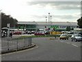
ASDA, Loughborough Road
The direct successor to the GEM superstore, which was the first of its kind in the Nottingham area, dating from the early 1970s. The current store has been built from new.
Image: © Alan Murray-Rust
Taken: 23 Sep 2008
0.12 miles

3
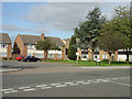
Rugby Road maisonettes
Typical 1950s maisonettes. Residents' parking is catered for by a communal parking area.
Image: © Alan Murray-Rust
Taken: 23 Sep 2008
0.15 miles

5
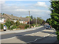
Rugby Road
One of several roads locally named after British public schools. This is the main access to the housing estates to the west of Loughborough Road.
Image: © Alan Murray-Rust
Taken: 23 Sep 2008
0.16 miles
6
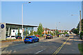
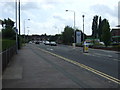
West Bridgford: obeying the speed limit
Loughborough Road on a fine September morning.
Image: © John Sutton
Taken: 7 Sep 2021
0.17 miles
7
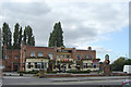
The Wolds
Fine roadhouse pub on Loughborough Road in largely unaltered Art Deco architecture.
Image: © Alan Murray-Rust
Taken: 23 Sep 2008
0.18 miles
9
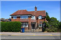
#181 Loughborough Road, 'Adams House'
Ordnance Survey records show that there was an benchmark on the front of this house, which may have been rebuilt with loss of the mark, see www.bench-marks.org.uk/bm82488
Image: © Roger Templeman
Taken: 14 May 2018
0.19 miles
10
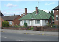
Green tiles
Colour-glazed pantiles were a particular fashion of the Art Deco period, but there are relatively few survivors, particularly as unaltered as this.
Image: © Alan Murray-Rust
Taken: 23 Sep 2008
0.19 miles