IMAGES TAKEN NEAR TO
Patrick Road, NOTTINGHAM, NG2 7QE
Introduction
This page details the photographs taken nearby to Patrick Road, NG2 7QE by members of the Geograph project.
The Geograph project started in 2005 with the aim of publishing, organising and preserving representative images for every square kilometre of Great Britain, Ireland and the Isle of Man.

There are currently over 7.5m images from over14,400 individuals and you can help contribute to the project by visiting https://www.geograph.org.uk
Image Map
Images are licensed for reuse under creativecommons.org/licenses/by-sa/2.0
Notes
- Clicking on the map will re-center to the selected point.
- The higher the marker number, the further away the image location is from the centre of the postcode.
Image Listing (317 Images Found)
Images are licensed for reuse under creativecommons.org/licenses/by-sa/2.0
Image
Details
Distance
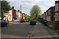
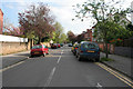
1
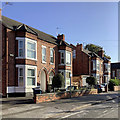
West Bridgford: morning sunlight, Patrick Road
These typical Bridgford villas are near the corners of Epperstone Road and William Road.
Image: © John Sutton
Taken: 18 Sep 2019
0.01 miles
2
A bend in the road
This is where Patrick Road turns into William Road. Photograph taken from the end of Epperstone Road.
Image: © Kate Jewell
Taken: 22 Apr 2009
0.02 miles
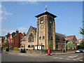
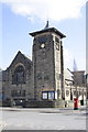
3
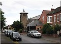
Patrick Road and the Methodist Church
West Bridgford Methodist Church, a distinctive landmark on Musters Road, was designed by the Nottingham architect R C Sutton and dates from 1899. The date accounts for the fin-de-siecle treatment of Gothic Revival - the curious pagoda roof to the tower and something of Art Nouveau in some of the proportions.
Image: © John Sutton
Taken: 12 Sep 2012
0.02 miles
4
Epperstone Road. West Bridgford
Looking towards Patrick Road.
Image: © Kate Jewell
Taken: 22 Apr 2009
0.03 miles
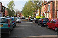
5
William Road, West Bridgford
Half way down this street of late Victorian semi-detached villas, many now used as student lets.
Image: © Kate Jewell
Taken: 22 Apr 2009
0.03 miles
6
West Bridgford Methodist Church
On the corner of Patrick Road and Musters Road, this church first opened its doors in 1888. It now has a modern extension (with the red roof) on Patrick Road.
Image: © Kate Jewell
Taken: 22 Apr 2009
0.03 miles
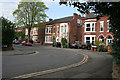
7
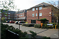
Epperstone Court, West Bridgford
Sheltered and retirement housing built in 1997.
Image: © Kate Jewell
Taken: 22 Apr 2009
0.03 miles
8
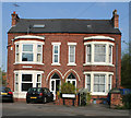
William Road, West Bridgford
A pair of late Victorian semi-detached villas on the corner with Patrick Road.
Image: © Kate Jewell
Taken: 22 Apr 2009
0.03 miles
9
William Road, West Bridgford
A street of late Victorian semi-detached villas, many now used as student lets.
View from the junction with Millicent Road.
Image: © Kate Jewell
Taken: 22 Apr 2009
0.03 miles
10
West Bridgford Methodist Church
This is the view across Musters Road. The vane on top of the small spire is an Ordnance Survey intersected station trig point, http://www.trigpointinguk.com/trigs/trig-details.php?t=11459
Image: © Roger Templeman
Taken: 3 Apr 2013
0.04 miles