IMAGES TAKEN NEAR TO
Musters Road, NOTTINGHAM, NG2 7PQ
Introduction
This page details the photographs taken nearby to Musters Road, NG2 7PQ by members of the Geograph project.
The Geograph project started in 2005 with the aim of publishing, organising and preserving representative images for every square kilometre of Great Britain, Ireland and the Isle of Man.

There are currently over 7.5m images from over14,400 individuals and you can help contribute to the project by visiting https://www.geograph.org.uk
Image Map
Images are licensed for reuse under creativecommons.org/licenses/by-sa/2.0
Notes
- Clicking on the map will re-center to the selected point.
- The higher the marker number, the further away the image location is from the centre of the postcode.
Image Listing (479 Images Found)
Images are licensed for reuse under creativecommons.org/licenses/by-sa/2.0
Image
Details
Distance
1
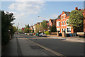
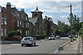
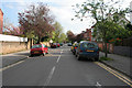
Musters Road, West Bridgford
This is one of the main wide tree-lined streets in the Victorian suburb of West Bridgford where many wealthy Nottingham industrialists lived. Strict planning rules imposed by the Musters family, when they sold their land for building, restricted density and imposed a minimum number of bedrooms. Smaller houses were permitted on side streets, and terraces were erected on roads such as Stratford Road for the servants, (see Image).
It is interesting to note that there are no "Streets" in West Bridgford. Originally many roads were name "Street" but this was felt to be too urban by the Victorian "planners". Thus all street names were changed from "Street" to "Road". The one exception is "Village Street" in Edwalton, a village that has been totally absorbed into the town of West Bridgford.
Image: © Kate Jewell
Taken: 22 Apr 2009
0.04 miles
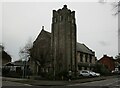
2
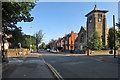
West Bridgford: Musters Road on a September morning
The Methodist church, on the corner of Patrick Road, is gothic revival with an Art Nouveau flavour and a bizarre pagoda roof to its tower. It was designed by the Nottingham architect R C Sutton.
Image: © John Sutton
Taken: 18 Sep 2019
0.04 miles
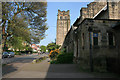
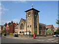
3
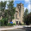
Friary United Reformed Church
The former Congregational Church stands at the corner of Musters Road and Millicent Road.
Image: © John Sutton
Taken: 3 Jul 2016
0.04 miles
4
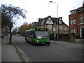
Bus on Musters Road, West Bridgford
Until March 2012, route 5 served the northern section of Musters Road, between Bridgford Road and Rectory Road in West Bridgford. This one has just passed the junction with Millicent Road on its way from Nottingham city centre to Gamston. Route 5 now operates via Central Avenue, so this view is no longer possible.
Image: © Richard Vince
Taken: 26 Nov 2011
0.04 miles
5
Sunday morning in Musters Road
Looking towards the Methodist Church, whose Gothic Revival tower is topped with a strange pagoda roof.
Image: © John Sutton
Taken: 3 Jul 2016
0.05 miles
6
Millicent Road, West Bridgford
With the Friary United Reformed Church to the right which opened in 1901 as the Friary Congregational Church.
Image: © Kate Jewell
Taken: 22 Apr 2009
0.05 miles
7
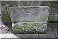
Benchmark on buttress of Friary United Reformed Church
Ordnance Survey cut mark benchmark described on the Bench Mark Database at www.bench-marks.org.uk/bm102880
Image: © Roger Templeman
Taken: 12 May 2018
0.05 miles
8
Friary United Reformed Church, West Bridgford
Built 1898 https://historicengland.org.uk/listing/the-list/list-entry/1045638?section=official-list-entry
Image: © Jonathan Thacker
Taken: 1 Jan 2023
0.05 miles
9
William Road, West Bridgford
A street of late Victorian semi-detached villas, many now used as student lets.
View from the junction with Millicent Road.
Image: © Kate Jewell
Taken: 22 Apr 2009
0.05 miles
10
West Bridgford Methodist Church
On the corner of Patrick Road and Musters Road, this church first opened its doors in 1888. It now has a modern extension (with the red roof) on Patrick Road.
Image: © Kate Jewell
Taken: 22 Apr 2009
0.05 miles