IMAGES TAKEN NEAR TO
Haven Close, NOTTINGHAM, NG2 7LP
Introduction
This page details the photographs taken nearby to Haven Close, NG2 7LP by members of the Geograph project.
The Geograph project started in 2005 with the aim of publishing, organising and preserving representative images for every square kilometre of Great Britain, Ireland and the Isle of Man.

There are currently over 7.5m images from over14,400 individuals and you can help contribute to the project by visiting https://www.geograph.org.uk
Image Map
Images are licensed for reuse under creativecommons.org/licenses/by-sa/2.0
Notes
- Clicking on the map will re-center to the selected point.
- The higher the marker number, the further away the image location is from the centre of the postcode.
Image Listing (35 Images Found)
Images are licensed for reuse under creativecommons.org/licenses/by-sa/2.0
Image
Details
Distance

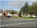
2
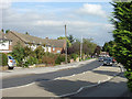
Rugby Road
One of several roads locally named after British public schools. This is the main access to the housing estates to the west of Loughborough Road.
Image: © Alan Murray-Rust
Taken: 23 Sep 2008
0.05 miles
3
Stowe Avenue
One of a number of roads in this part of West Bridgford named after British public schools.
Image: © Alan Murray-Rust
Taken: 23 Sep 2008
0.10 miles
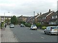
4
Kingswood Road
1950s/60s housing development.
Image: © Alan Murray-Rust
Taken: 23 Sep 2008
0.11 miles
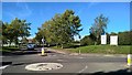
5
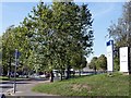
Entrance to Rushcliffe Arena
Multi-sport centre in West Bridgford
Image: © Graham Hogg
Taken: 25 Sep 2018
0.13 miles
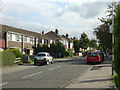
6
Rugby Road maisonettes
Typical 1950s maisonettes. Residents' parking is catered for by a communal parking area.
Image: © Alan Murray-Rust
Taken: 23 Sep 2008
0.14 miles
8
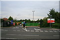
Household Waste and Recycling Site, Rushcliffe
Now run by the same company as those in Broxtowe and Erewash.
Image: © David Lally
Taken: 8 Sep 2008
0.15 miles
9

Rushcliffe Arena
West Bridgford leisure centre, approached from Rugby Road.
Image: © John Sutton
Taken: 6 Apr 2019
0.17 miles
10
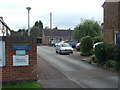
Rugby Road Community Centre
Included as part of a development of maisonette blocks.
Image: © Alan Murray-Rust
Taken: 23 Sep 2008
0.17 miles