IMAGES TAKEN NEAR TO
Millicent Road, NOTTINGHAM, NG2 7LD
Introduction
This page details the photographs taken nearby to Millicent Road, NG2 7LD by members of the Geograph project.
The Geograph project started in 2005 with the aim of publishing, organising and preserving representative images for every square kilometre of Great Britain, Ireland and the Isle of Man.

There are currently over 7.5m images from over14,400 individuals and you can help contribute to the project by visiting https://www.geograph.org.uk
Image Map
Images are licensed for reuse under creativecommons.org/licenses/by-sa/2.0
Notes
- Clicking on the map will re-center to the selected point.
- The higher the marker number, the further away the image location is from the centre of the postcode.
Image Listing (651 Images Found)
Images are licensed for reuse under creativecommons.org/licenses/by-sa/2.0
Image
Details
Distance
1
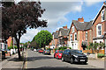
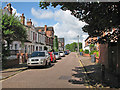
Millicent Road
Solid Victorian villas on each side.
Image: © John Sutton
Taken: 17 Jul 2016
0.01 miles
2
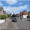
West Bridgford: on Millicent Road
Looking towards Musters Road and Friary United Reformed Church from near the corner of Henry Road.
Image: © John Sutton
Taken: 12 May 2019
0.01 miles
3
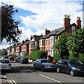
West Bridgford: Henry Road
In the last quarter of the 19th century and the early years of the 20th Bridgford expanded from a small village to a large and prosperous suburb with its own Urban District Council. These genteel red-brick villas are typical.
Image: © John Sutton
Taken: 3 Jul 2016
0.03 miles
5
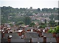
Wet Bridgford and Wilford Hill
A very heavy shower had interrupted play on the third afternoon of the Nottinghamshire-Sussex match at Trent Bridge. This long zoom view of wet West Bridgford from the Radcliffe Road End shows in the foreground houses in the roads off Loughborough Road, and beyond them newer houses on the northern slope of Wilford Hill, which is topped by the chapel at the Southern Cemetery, about two miles away. Much of Bridgford was built in the late Victorian and Edwardian periods; expansion southwards to Edwalton and Wilford Hill came between and after the wars.
Image: © John Sutton
Taken: 29 Jul 2012
0.05 miles
6
West Bridgford: Rushworth Avenue
The white terrace with pediments is unlike other houses in Victorian and Edwardian Bridgford - I have a feeling that it may be slightly earlier than most of them. The view is from the corner of Musters Road, looking towards Loughborough Road.
Image: © John Sutton
Taken: 3 Jul 2016
0.05 miles
7
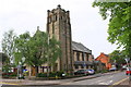
Friary United Reformed Church, Millicent Road
There is an OS benchmark Image on the road face of the right hand buttress on the near corner of the church's tower
Image: © Roger Templeman
Taken: 12 May 2018
0.06 miles
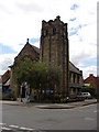
8
West Bridgford: Friary United Reformed Church
The former Congregational Church (1901) stands at the corner of Millicent Road and Musters Road. Image] shows the Musters Road side on a sunnier day than this one.
Image: © John Sutton
Taken: 27 Sep 2022
0.06 miles
9
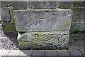
Benchmark on buttress of Friary United Reformed Church
Ordnance Survey cut mark benchmark described on the Bench Mark Database at www.bench-marks.org.uk/bm102880
Image: © Roger Templeman
Taken: 12 May 2018
0.06 miles
10
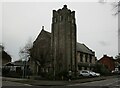
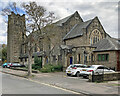
Friary United Reformed Church, West Bridgford
Built 1898 https://historicengland.org.uk/listing/the-list/list-entry/1045638?section=official-list-entry
Image: © Jonathan Thacker
Taken: 1 Jan 2023
0.06 miles