IMAGES TAKEN NEAR TO
Melrose Gardens, NOTTINGHAM, NG2 7FQ
Introduction
This page details the photographs taken nearby to Melrose Gardens, NG2 7FQ by members of the Geograph project.
The Geograph project started in 2005 with the aim of publishing, organising and preserving representative images for every square kilometre of Great Britain, Ireland and the Isle of Man.

There are currently over 7.5m images from over14,400 individuals and you can help contribute to the project by visiting https://www.geograph.org.uk
Image Map
Images are licensed for reuse under creativecommons.org/licenses/by-sa/2.0
Notes
- Clicking on the map will re-center to the selected point.
- The higher the marker number, the further away the image location is from the centre of the postcode.
Image Listing (38 Images Found)
Images are licensed for reuse under creativecommons.org/licenses/by-sa/2.0
Image
Details
Distance
1
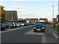
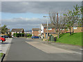
Stanhome Square, east side
The concrete section of roadway on the right is a reminder that this was once the terminus of the bus service to Wolds Estate.
Image: © Alan Murray-Rust
Taken: 10 Oct 2021
0.09 miles
2
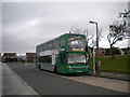
Bus in Stanhome Square, Wolds Estate
For just over five months in 2012, buses terminated in Stanhome Square on the Wolds Estate for the first time in some years. This shot of Nottingham City Transport 951, an East Lancs bodied Scania N230UD, was taken on the last day of the short existence of route 10A (effectively a short working of route 10 to Ruddington). The concrete road surface at the bus stop indicates that it was intended to be a bus terminus, initially for West Bridgford UDC route 15.
Image: © Richard Vince
Taken: 1 Sep 2012
0.09 miles
3
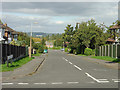
Lansdowne Drive
Cul-de-sac in the Wolds Estate off Stanhome Drive.
Image: © Alan Murray-Rust
Taken: 23 Sep 2008
0.09 miles
4
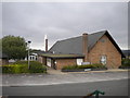
LDS church, West Bridgford
The Church of Jesus Christ of Latter Day Saints in West Bridgford has a less than prominent location in the middle of Stanhome Square in Wolds Estate.
Image: © Richard Vince
Taken: 1 Sep 2012
0.09 miles
5
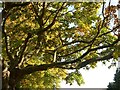
Autumn is with us ? 1
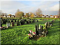
Lime trees alongside the Southern Cemetery.
Image: © Alan Murray-Rust
Taken: 10 Oct 2021
0.10 miles
6
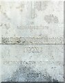
Inscription on the Birkin memorial
See http://www.geograph.org.uk/photo/6989019 for location. The photo has made the inscription easier to make out than it is in real life.
Image: © Alan Murray-Rust
Taken: 10 Oct 2021
0.10 miles
7
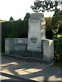
Birkin memorial outside the Southern Cemetery
This looks as if it ought to be a war memorial but is not, and is in the form of a drinking fountain (no longer functioning). It is inscribed 'In memory of Hilda Mary Birkin (May) of Ruddington Grange 1926' http://www.geograph.org.uk/photo/6989021 and is Listed Grade II.
Image: © Alan Murray-Rust
Taken: 10 Oct 2021
0.10 miles
8
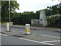
Stanhome Square
The concrete apron is the only evidence that this was once a main bus terminus for the service to Nottingham. Buses now continue the full length of Greythorn Drive on their way to Ruddington.
Image: © Alan Murray-Rust
Taken: 23 Sep 2008
0.10 miles
10
Memorial on Loughborough Road
Adjacent to the cemetery, this might be expected to be a war memorial, but is in fact a memorial to a private person, Florence Mary Birkin.
Image: © Alan Murray-Rust
Taken: 23 Sep 2008
0.11 miles