IMAGES TAKEN NEAR TO
Hedgehog Gardens, NOTTINGHAM, NG2 7BF
Introduction
This page details the photographs taken nearby to Hedgehog Gardens, NG2 7BF by members of the Geograph project.
The Geograph project started in 2005 with the aim of publishing, organising and preserving representative images for every square kilometre of Great Britain, Ireland and the Isle of Man.

There are currently over 7.5m images from over14,400 individuals and you can help contribute to the project by visiting https://www.geograph.org.uk
Image Map
Images are licensed for reuse under creativecommons.org/licenses/by-sa/2.0
Notes
- Clicking on the map will re-center to the selected point.
- The higher the marker number, the further away the image location is from the centre of the postcode.
Image Listing (37 Images Found)
Images are licensed for reuse under creativecommons.org/licenses/by-sa/2.0
Image
Details
Distance
1
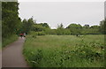
Nottingham - NG2 (Wilford Area)
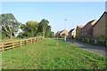
A section of footpath on the former Rushcliffe Council municipal waste tip off Rugby Road, looking in the direction of Wilford Road. Once filled the tip was levelled off and covered, in part by ash from the Ratcliffe-on-Soar coal-fired power station, and it is currently open meadow land, albeit semi-permanently under threat of being built upon.
Image: © David Hallam-Jones
Taken: 2 Jun 2012
0.03 miles
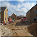
2
Wilford Fields: a new estate expanding
A view from the path from Rugby Road to Wilford Lane (ahead). Grid references are as accurate as I can judge them as the course of the path has been altered slightly and mapping has yet to keep pace with building.
Image: © John Sutton
Taken: 15 Jul 2019
0.04 miles
3
West Bridgford: the edge of Wilford Fields
This estate has been built on playing fields in recent years. The picture was taken from the path which links Wilford Lane (left) to Rushcliffe Arena and Rugby Road.
Image: © John Sutton
Taken: 7 Sep 2021
0.04 miles
4
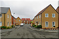
West Bridgford: Nightingale Grove, Wilford Fields
Looking towards Magpie Crescent. Image] shows these houses being built in 2019.
Image: © John Sutton
Taken: 6 Sep 2022
0.05 miles
5
West Bridgford: the path past Wilford Fields
The Wilford Fields estate has gone up in recent years. Image] shows some of these houses being built in 2019. The path runs from Rugby Road to Wilford Lane (ahead).
Image: © John Sutton
Taken: 7 Sep 2021
0.05 miles
6
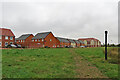
West Bridgford: the edge of Wilford Fields estate
Looking towards Magpie Crescent on a cloudy early-September morning. The pierced metal sphere on the pipe on the right was rotating gently and I wondered if it is a modern sewer vent pipe. There is another out of the picture to the left.
Image: © John Sutton
Taken: 6 Sep 2022
0.05 miles
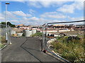
7
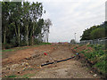
West Bridgford: re-routing a path
The existing path (on the other side of the Heras fencing on the right) runs from Rugby Road to Wilford Lane (ahead), skirting the former playing fields which are being built on and will be known as Wilford Fields. Some of the half-built houses show on the skyline.
Image: © John Sutton
Taken: 5 Sep 2018
0.05 miles
8
Wilford Fields: new houses
Seen from near the Wilford Lane end of the path from Rugby Road and Rushcliffe Arena. Grid references are as accurate as I can judge them as mapping has yet to keep pace with building.
Image: © John Sutton
Taken: 15 Jul 2019
0.08 miles
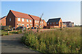
9
Wilford Fields taking shape
A new estate being built on former playing fields off Wilford Lane. The picture was taken through the site fence from the path from Wilford Lane (left) to Rushcliffe Arena and Rugby Road. Grid references are as accurate as I can judge them as mapping has yet to keep pace with building.
Image: © John Sutton
Taken: 15 Jul 2019
0.08 miles
10

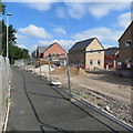
Building work at Wilford Fields
This is a new housing estate off Wilford Lane, seen from the footpath from Wilford Lane to Rugby Road and Rushcliffe Arena. Image] shows part of the site in September 2018.
Image: © John Sutton
Taken: 6 Apr 2019
0.09 miles