IMAGES TAKEN NEAR TO
Ralf Close, NOTTINGHAM, NG2 7AZ
Introduction
This page details the photographs taken nearby to Ralf Close, NG2 7AZ by members of the Geograph project.
The Geograph project started in 2005 with the aim of publishing, organising and preserving representative images for every square kilometre of Great Britain, Ireland and the Isle of Man.

There are currently over 7.5m images from over14,400 individuals and you can help contribute to the project by visiting https://www.geograph.org.uk
Image Map
Images are licensed for reuse under creativecommons.org/licenses/by-sa/2.0
Notes
- Clicking on the map will re-center to the selected point.
- The higher the marker number, the further away the image location is from the centre of the postcode.
Image Listing (27 Images Found)
Images are licensed for reuse under creativecommons.org/licenses/by-sa/2.0
Image
Details
Distance
1
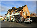
Shops, Boundary Road, West Bridgford
Image: © Jonathan Thacker
Taken: 19 Nov 2022
0.03 miles
2
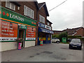
Local Shops
Boundary Road, West Bridgford.
Image: © David Lally
Taken: 17 Sep 2009
0.03 miles
3
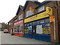
Who Will Let the Letters?
The letting agency branch has closed. So it's up for let?
Image: © David Lally
Taken: 17 Sep 2009
0.03 miles
4
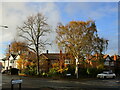
Silver birch, Boundary Road, West Bridgford
Image: © Jonathan Thacker
Taken: 19 Nov 2022
0.05 miles
5
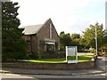
St Paul's, Boundary Road
Founded in the 1960s to serve the growing housing developments in souther and western West Bridgford. This is the end of the church hall.
Image: © Alan Murray-Rust
Taken: 10 Oct 2021
0.07 miles

7
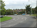
Loughborough Road at Boundary Road
The sweeping curve marks the point at which Loughborough Road diverges from the old direct route over the top of Wilford Hill. Boundary Road would originally have marked the boundary of West Bridgford.
Image: © Alan Murray-Rust
Taken: 23 Sep 2008
0.11 miles
8
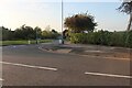
Boundary Road at the junction of Loughborough Road
Image: © David Howard
Taken: 8 May 2022
0.12 miles
9
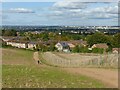
Wilford Hill
Recreating this 'First' for the square https://www.geograph.org.uk/photo/36212 .
The alignment of the path has changed as a result of the land on the right having been earmarked for housing development.
Image: © Alan Murray-Rust
Taken: 10 Oct 2021
0.14 miles
10
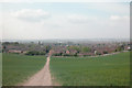
Wilford Hill
Footpath through farmland looking north to Nottingham.
Image: © Dennis Turner
Taken: 20 Apr 2003
0.14 miles