IMAGES TAKEN NEAR TO
Chaworth Road, NOTTINGHAM, NG2 7AE
Introduction
This page details the photographs taken nearby to Chaworth Road, NG2 7AE by members of the Geograph project.
The Geograph project started in 2005 with the aim of publishing, organising and preserving representative images for every square kilometre of Great Britain, Ireland and the Isle of Man.

There are currently over 7.5m images from over14,400 individuals and you can help contribute to the project by visiting https://www.geograph.org.uk
Image Map
Images are licensed for reuse under creativecommons.org/licenses/by-sa/2.0
Notes
- Clicking on the map will re-center to the selected point.
- The higher the marker number, the further away the image location is from the centre of the postcode.
Image Listing (86 Images Found)
Images are licensed for reuse under creativecommons.org/licenses/by-sa/2.0
Image
Details
Distance
1
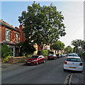
West Bridgford: South Road
A street of typical Bridgford red-brick villas which runs from Loughborough Road to Musters Road (ahead).
Image: © John Sutton
Taken: 7 Sep 2021
0.07 miles
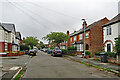
2
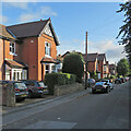
West Bridgford: on North Road
North Road runs from Loughborough Road to Melton Road (ahead). At the Melton Road end most of the houses are smaller than these substantial villas.
Image: © John Sutton
Taken: 23 Sep 2021
0.07 miles
3
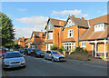
West Bridgford: North Road
North Road runs from Melton Road to Loughborough Road (ahead). At the Melton Road end most of the houses are smaller than these substantial villas.
Image: © John Sutton
Taken: 23 Sep 2021
0.08 miles
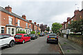
4
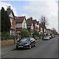
West Bridgford: Chaworth Road
A long straight road of Victorian and Edwardian villas, some quite large, which runs from Loughborough Road to Musters Road (ahead).
Image: © John Sutton
Taken: 6 Apr 2019
0.09 miles
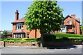
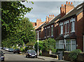
5
West Bridgford: Hampton Road
Photographed on an overcast early-September morning.
Image: © John Sutton
Taken: 6 Sep 2022
0.09 miles
6
Junction of South Road and Musters Road at #178 Musters Road
There is an OS benchmark Image on the corner of the stone wall
Image: © Roger Templeman
Taken: 14 May 2018
0.11 miles
7
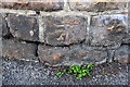
Benchmark on wall outside #178 Musters Road at South Road junction
Ordnance Survey cut mark benchmark levelled at 24.664m above Newlyn Datum with additional information to be found on the Bench Mark Database at www.bench-marks.org.uk/bm112895
Image: © Roger Templeman
Taken: 14 May 2018
0.11 miles
8
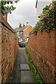
West Bridgford: North Road to Carlyle Road
In Nottingham alleys like this are called twitchels.
Image: © John Sutton
Taken: 27 Jul 2023
0.11 miles
9
West Bridgford: along Carlyle Road
Bridgford mushroomed in the last twenty years of the nineteenth century and the Edwardian period (and again between the wars and thereafter).
Image: © John Sutton
Taken: 27 Jul 2023
0.12 miles
10
North Road
Together with the parallel Chaworth and South Roads, these mark the limit of residential development before the first World War.
Image: © Alan Murray-Rust
Taken: 23 Sep 2008
0.12 miles