IMAGES TAKEN NEAR TO
Lonscale Close, NOTTINGHAM, NG2 6SU
Introduction
This page details the photographs taken nearby to Lonscale Close, NG2 6SU by members of the Geograph project.
The Geograph project started in 2005 with the aim of publishing, organising and preserving representative images for every square kilometre of Great Britain, Ireland and the Isle of Man.

There are currently over 7.5m images from over14,400 individuals and you can help contribute to the project by visiting https://www.geograph.org.uk
Image Map
Images are licensed for reuse under creativecommons.org/licenses/by-sa/2.0
Notes
- Clicking on the map will re-center to the selected point.
- The higher the marker number, the further away the image location is from the centre of the postcode.
Image Listing (46 Images Found)
Images are licensed for reuse under creativecommons.org/licenses/by-sa/2.0
Image
Details
Distance
1
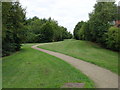
Green Corridor
Between Edwalton and Gamston
Image: © Oxymoron
Taken: 7 Aug 2008
0.08 miles
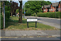
2
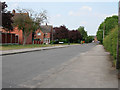
Leahurst Road
With Leahurst Gardens to the left.
Image: © Kate Jewell
Taken: 4 Jun 2010
0.13 miles
3
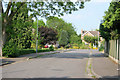
Grange Park
Grange Park turns to the right by the house at the end, which is in the next square north.
Image: © Kate Jewell
Taken: 4 Jun 2010
0.14 miles
4
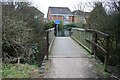
Footbridge
Over a small brook near the Grantham Canal. It joins the end of Stamford Road to the newer estates around Gamston.
Image: © David Lally
Taken: 27 Jan 2010
0.17 miles
5
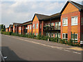
Hilton Grange
On Hilton Crescent: These 62 care assisted apartments were built in 2007.
Image: © Kate Jewell
Taken: 4 Jun 2010
0.18 miles
6
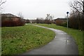
Foot and cycle path
In Gamston. The path passes to the west of the Morrisons supermarket, which can be seen just right of centre.
Image: © David Lally
Taken: 22 Jan 2010
0.18 miles
7
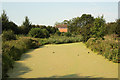
Grantham Canal
View west from Elnor's Bridge, also known as Minor's Bridge (No.6) at the tail of Gamston Lock on the disused Grantham Canal.
Image: © Richard Croft
Taken: 3 Sep 2012
0.19 miles
8
Junction of Covert Road with Leahurst Road
Hilton Grange sheltered housing scheme on the right.
Image: © Kate Jewell
Taken: 4 Jun 2010
0.19 miles
9
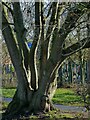
Ash tree alongside the Grantham Canal
This looks to have regrown from the stump of a tree felled many years ago.
Image: © Alan Murray-Rust
Taken: 10 Dec 2021
0.19 miles
10
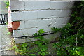
Benchmark on #4 Hilton Crescent
Ordnance Survey cut mark benchmark described on the Bench Mark Database at https://www.bench-marks.org.uk/bm102473
Image: © Roger Templeman
Taken: 12 May 2018
0.19 miles