IMAGES TAKEN NEAR TO
Fleetwith Close, NOTTINGHAM, NG2 6RR
Introduction
This page details the photographs taken nearby to Fleetwith Close, NG2 6RR by members of the Geograph project.
The Geograph project started in 2005 with the aim of publishing, organising and preserving representative images for every square kilometre of Great Britain, Ireland and the Isle of Man.

There are currently over 7.5m images from over14,400 individuals and you can help contribute to the project by visiting https://www.geograph.org.uk
Image Map
Images are licensed for reuse under creativecommons.org/licenses/by-sa/2.0
Notes
- Clicking on the map will re-center to the selected point.
- The higher the marker number, the further away the image location is from the centre of the postcode.
Image Listing (44 Images Found)
Images are licensed for reuse under creativecommons.org/licenses/by-sa/2.0
Image
Details
Distance
1
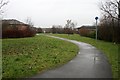
Foot and cycle path
In Gamston. The path passes to the west of the Morrisons supermarket, which can be seen just right of centre.
Image: © David Lally
Taken: 22 Jan 2010
0.10 miles
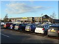
2
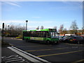
Bus at Morrisons, Gamston
A bus pulls in to the bus stop at the Morrisons supermarket in Gamston. As is so often the case, one has to walk through the car park between the bus stop and the supermarket entrance. The exit from the petrol station is in the foreground.
Image: © Richard Vince
Taken: 26 Nov 2011
0.12 miles
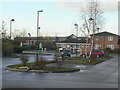
3
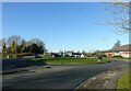
Roundabout at Beckside and Ambleside
Also the entrance to the Morrison's superstore.
Image: © Alan Murray-Rust
Taken: 10 Dec 2021
0.13 miles
4
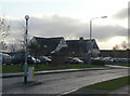
The Goose at Gamston
A large public house built as part of the major housing development at Gamston in the 1980s and 1990s.
Image: © Alan Murray-Rust
Taken: 13 Dec 2009
0.16 miles
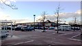
6
Gamston superstore
This appears to have been an essential part of the plan when the extensive Gamston housing development of the 1980s and 90s was planned.
Image: © Alan Murray-Rust
Taken: 13 Dec 2009
0.16 miles
7
Gamston Health Centre
Community based facilities for the extensive Gamston development of the 1980s and 90s are clustered in this area, centred round the large superstore in the background.
Image: © Alan Murray-Rust
Taken: 13 Dec 2009
0.16 miles
8
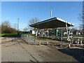
New electric car charging point, Gamston retail centre
Nearly ready to go into service.
Image: © Alan Murray-Rust
Taken: 10 Dec 2021
0.17 miles
9
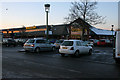
Morrisons superstore at Gamston
Just off the Gamston Lings Bar Road.
Photograph taken at dusk.
Image: © Kate Jewell
Taken: 7 Jan 2010
0.17 miles
10
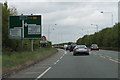
A52 near Gamston
Approaching two junctions.
Image: © J.Hannan-Briggs
Taken: 14 May 2013
0.17 miles