IMAGES TAKEN NEAR TO
Rossett Close, NOTTINGHAM, NG2 6QJ
Introduction
This page details the photographs taken nearby to Rossett Close, NG2 6QJ by members of the Geograph project.
The Geograph project started in 2005 with the aim of publishing, organising and preserving representative images for every square kilometre of Great Britain, Ireland and the Isle of Man.

There are currently over 7.5m images from over14,400 individuals and you can help contribute to the project by visiting https://www.geograph.org.uk
Image Map (Loading...)


Getting Data...Please wait
Leaflet Map data © OpenStreetMap
Images are licensed for reuse under creativecommons.org/licenses/by-sa/2.0
Notes
- Clicking on the map will re-center to the selected point.
- The higher the marker number, the further away the image location is from the centre of the postcode.
Image Listing (74 Images Found)
Images are licensed for reuse under creativecommons.org/licenses/by-sa/2.0
Image
Details
Distance
1
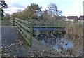
Grantham Canal
The concrete culvert is where the canal disappears under Ambleside road, to reappear the other side of the A52 about 150 m away.
Image: © Oxymoron
Taken: 23 Jul 2008
0.06 miles
2
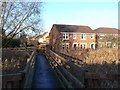
Footbridge at Gamston
Crossing the Grantham Canal near the superstore. This is the one footbridge in the area which is not on the site of an earlier one.
Image: © Alan Murray-Rust
Taken: 13 Dec 2009
0.08 miles
3
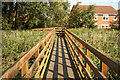
Lings Bar footbridge
Footbridge between Lings Bar and Morrison's supermarket, across the disused Grantham Canal
Image: © Richard Croft
Taken: 3 Sep 2012
0.08 miles
4
Footbridge 6b crossing the Grantham Canal
Image: © Mat Fascione
Taken: 12 Nov 2017
0.08 miles
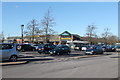
5
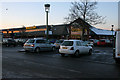
Morrisons superstore at Gamston
Just off the Gamston Lings Bar Road.
Photograph taken at dusk.
Image: © Kate Jewell
Taken: 7 Jan 2010
0.09 miles
6
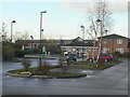
Gamston Health Centre
Community based facilities for the extensive Gamston development of the 1980s and 90s are clustered in this area, centred round the large superstore in the background.
Image: © Alan Murray-Rust
Taken: 13 Dec 2009
0.09 miles
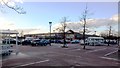
8
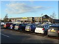
Gamston superstore
This appears to have been an essential part of the plan when the extensive Gamston housing development of the 1980s and 90s was planned.
Image: © Alan Murray-Rust
Taken: 13 Dec 2009
0.10 miles
9
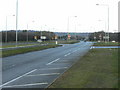
Lings Bar Road
The eastern leg of the Nottingham Southern Ring Road looking towards Radcliffe Road. The line of the Grantham Canal passes under where the photographer is standing.
Image: © Alan Murray-Rust
Taken: 13 Dec 2009
0.10 miles