IMAGES TAKEN NEAR TO
Radcliffe Road, NOTTINGHAM, NG2 6NR
Introduction
This page details the photographs taken nearby to Radcliffe Road, NG2 6NR by members of the Geograph project.
The Geograph project started in 2005 with the aim of publishing, organising and preserving representative images for every square kilometre of Great Britain, Ireland and the Isle of Man.

There are currently over 7.5m images from over14,400 individuals and you can help contribute to the project by visiting https://www.geograph.org.uk
Image Map
Images are licensed for reuse under creativecommons.org/licenses/by-sa/2.0
Notes
- Clicking on the map will re-center to the selected point.
- The higher the marker number, the further away the image location is from the centre of the postcode.
Image Listing (78 Images Found)
Images are licensed for reuse under creativecommons.org/licenses/by-sa/2.0
Image
Details
Distance
1
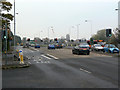
Radcliffe Road at Gamston
Formerly the A52, now the A6011, this is the main trunk road exit from Nottingham in an easterly direction.
Image: © Alan Murray-Rust
Taken: 13 Nov 2011
0.05 miles
2
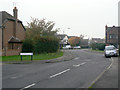
Kirkstone Drive
Typical residential road in this area of 1980s development. It links to the remains of the old hamlet of Gamston on the section of the old Tollerton Road cut off when the Lings Bar Road bypass section of the A52 was created.
Image: © Alan Murray-Rust
Taken: 13 Nov 2011
0.06 miles
3
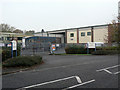
Petfood distribution centre
The only industrial site in the Gamston development of the 1990s, based on Ambleside and Beckside.
Image: © Alan Murray-Rust
Taken: 13 Nov 2011
0.09 miles
4
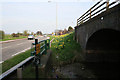
At Gamston Bridge
Looking east from the twin bridge (number 4 and 4A) you can easily see what the problem is to the reopening of the Grantham Canal at this point. Bridge number 4A, on the right, carrying the Nottingham bound carriageway of Radford Road over the canal, is high enough to allow craft to pass underneath. A major obstacle to the reopening of the canal is Bridge 4 which can be seen on the left. This was constructed as a culvert during the dualling of Radcliffe Road with scant regard for future use of the waterway. This is the main reason why a feasibility study to look into alternative routes to the River Trent was carried out in 2009.
Image: © Kate Jewell
Taken: 10 Apr 2010
0.11 miles
5
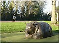
Not a Raging Bull
Timber sculpture in the Ambleside Play Park, Gamston.
Image: © Alan Murray-Rust
Taken: 10 Dec 2021
0.12 miles
6
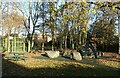
Stone circle, Gamston
Nothing ancient about this; it forms part of the Ambleside Play Park.
Image: © Alan Murray-Rust
Taken: 10 Dec 2021
0.14 miles
7
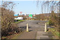
Cycle Route at the end of Old Tollerton Road
A6011 ahead.
Image: © J.Hannan-Briggs
Taken: 2 Feb 2013
0.14 miles
8
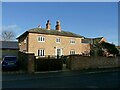
Manor Farmhouse, Gamston
An attractive early 19th century house, long divorced from any farming activity.
Image: © Alan Murray-Rust
Taken: 10 Dec 2021
0.15 miles
9
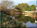
Winding hole, Gamston
Just to the north of Gamston Bridge. The extra width enabled boats to be turned round here.
Image: © Alan Murray-Rust
Taken: 13 Dec 2009
0.15 miles
10
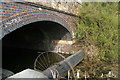
Obstruction at Gamston Bridge
This is Bridge number 4A, carrying the Nottingham bound carriageway of Radford Road over the Grantham Canal. It is high enough to allow craft to pass underneath, that is if there wasn't a large sewerage pipe crossing just above water level. The metal structures which look like some sort of turning device are to stop people walking on the pipe.
Image: © Kate Jewell
Taken: 10 Apr 2010
0.15 miles