IMAGES TAKEN NEAR TO
Mountsorrel Drive, NOTTINGHAM, NG2 6LJ
Introduction
This page details the photographs taken nearby to Mountsorrel Drive, NG2 6LJ by members of the Geograph project.
The Geograph project started in 2005 with the aim of publishing, organising and preserving representative images for every square kilometre of Great Britain, Ireland and the Isle of Man.

There are currently over 7.5m images from over14,400 individuals and you can help contribute to the project by visiting https://www.geograph.org.uk
Image Map
Images are licensed for reuse under creativecommons.org/licenses/by-sa/2.0
Notes
- Clicking on the map will re-center to the selected point.
- The higher the marker number, the further away the image location is from the centre of the postcode.
Image Listing (52 Images Found)
Images are licensed for reuse under creativecommons.org/licenses/by-sa/2.0
Image
Details
Distance
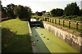
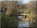
1
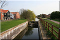
Bridgford Lock, Grantham Canal
Lock number 2 on this disused canal. It is believed that the lock gates here were removed in the 1950s. Luckily someone had the foresight to build a weir at this time to maintain the water level otherwise this stretch of the canal would be dry.
Image: © Kate Jewell
Taken: 10 Apr 2010
0.10 miles
2
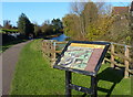
Information board along the Grantham Canal
Next to the derelict Gamston Lock No 2 at Gamston.
Image: © Mat Fascione
Taken: 12 Nov 2017
0.11 miles
3
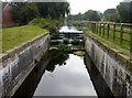
Gamston Lock, #2 on the Grantham Canal
The canal runs for 33 miles between Grantham and the River Trent at West Bridgford. The canal, which opened in 1797 and was abandoned in 1936, is now mostly derelict. The canal had 18 locks, most of which have been demolished. Since the 1970s, the Grantham Canal Society have been working towards restoring the canal, and two stretches are now navigable.
Image: © Graham Hogg
Taken: 11 Oct 2016
0.11 miles
5
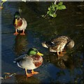
Three Mallard
Standing on the upper cill of the remains of Bridgford Lock https://www.geograph.org.uk/photo/1623154 on the Grantham Canal
Image: © Alan Murray-Rust
Taken: 10 Dec 2021
0.12 miles
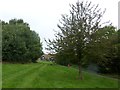
6
Bridgford Lock No.2
The lower of the pair of locks as the Grantham Canal passes through the Gamston development.
Image: © Alan Murray-Rust
Taken: 13 Dec 2009
0.12 miles
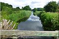
7
Grantham Canal at Gamston
Forming the boundary between West Bridgford (on the left) and Gamston (on the right), this disused canal has become an important recreational resource even though it is no longer navigable.
Image: © Kate Jewell
Taken: 10 Apr 2010
0.12 miles
8
Bridgford Lock
Lock number 2 on the disused Grantham Canal
Image: © Richard Croft
Taken: 3 Sep 2012
0.12 miles
9
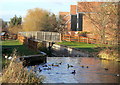
Bridge No.5
Footbridge at the end of Lindale Close on the site of an earlier swing bridge across the Grantham Canal.
Image: © Alan Murray-Rust
Taken: 13 Dec 2009
0.12 miles
10
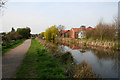
Grantham Canal
On the outskirts of Gamston.
Image: © David Lally
Taken: 24 Jun 2016
0.13 miles