IMAGES TAKEN NEAR TO
Leverton Court, NOTTINGHAM, NG2 6FL
Introduction
This page details the photographs taken nearby to Leverton Court, NG2 6FL by members of the Geograph project.
The Geograph project started in 2005 with the aim of publishing, organising and preserving representative images for every square kilometre of Great Britain, Ireland and the Isle of Man.

There are currently over 7.5m images from over14,400 individuals and you can help contribute to the project by visiting https://www.geograph.org.uk
Image Map
Images are licensed for reuse under creativecommons.org/licenses/by-sa/2.0
Notes
- Clicking on the map will re-center to the selected point.
- The higher the marker number, the further away the image location is from the centre of the postcode.
Image Listing (23 Images Found)
Images are licensed for reuse under creativecommons.org/licenses/by-sa/2.0
Image
Details
Distance
1
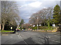
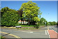
Melton Road, West Bridgford
Looking north, towards Nottingham, from the end of Ludlow Hill Road (left foreground).
Image: © Richard Vince
Taken: 8 Feb 2014
0.02 miles
2

Junction of Stamford Road with Melton Road
There is an OS benchmark Image on the stone wall right of the fire hydrant sign
Image: © Luke Shaw
Taken: 12 May 2018
0.03 miles
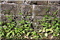
3
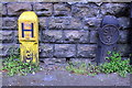
Benchmark on Stamford Road wall of #151 Melton Road
Image: © Luke Shaw
Taken: 12 May 2018
0.03 miles
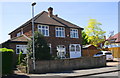
4
Mellors Road, West Bridgford
Seen from the junction with Melton Road.
Image: © Richard Vince
Taken: 8 Feb 2014
0.07 miles
5
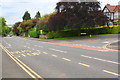
Junction of Dovedale Road and Melton Road
In 1856 the Ordnance Survey cut a benchmark on a kerb stone here when the main road ran through fields. See www.bench-marks.org.uk/bm20194 for more information.
Image: © Luke Shaw
Taken: 12 May 2018
0.07 miles
6
Junction of Melton Road and Mowbray Gardens
There is an OS benchmark Image on the corner of the stone wall right of the road name sign
Image: © Roger Templeman
Taken: 14 May 2018
0.12 miles
7
Benchmark on stone wall at Mowbray Gardens / Melton Road junction
Ordnance Survey cut mark benchmark levelled at 44.202m above Newlyn Datum with additional information on the Bench Mark Database at www.bench-marks.org.uk/bm112890
Image: © Roger Templeman
Taken: 14 May 2018
0.13 miles
8
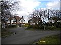
Roundabout on Dovedale Road, West Bridgford
Image: © Richard Vince
Taken: 8 Feb 2014
0.13 miles
9
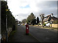
#4 Burleigh Road
There is an OS benchmark Image on the fronting wall between the metal gates and the lamppost, partly behind the cable guard
Image: © Roger Templeman
Taken: 14 May 2018
0.18 miles
10
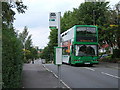
no. 6 bus
looking north from the junction of Trevor Road and Stamford Road, West Bridgford
Image: © Catherine Davis
Taken: 15 Aug 2006
0.19 miles