IMAGES TAKEN NEAR TO
Rectory Road, NOTTINGHAM, NG2 6BN
Introduction
This page details the photographs taken nearby to Rectory Road, NG2 6BN by members of the Geograph project.
The Geograph project started in 2005 with the aim of publishing, organising and preserving representative images for every square kilometre of Great Britain, Ireland and the Isle of Man.

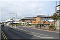
There are currently over 7.5m images from over14,400 individuals and you can help contribute to the project by visiting https://www.geograph.org.uk
Image Map
Images are licensed for reuse under creativecommons.org/licenses/by-sa/2.0
Notes
- Clicking on the map will re-center to the selected point.
- The higher the marker number, the further away the image location is from the centre of the postcode.
Image Listing (188 Images Found)
Images are licensed for reuse under creativecommons.org/licenses/by-sa/2.0
Image
Details
Distance
1
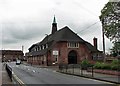
West Bridgford Community Hall and Bridgford Road
The Parish Rooms date from the 1920s and are very much of the period. Kate Jewell's Image] shows the building from a different angle and on a brighter day.
Image: © John Sutton
Taken: 9 May 2012
0.03 miles
2
West Bridgford: Bridgford Road and Lutterell Hall
Lutterell Hall (formerly West Bridgford Community Hall) is used by a number of local groups and Bridgfordians are up in arms at a Rushcliffe Borough Council proposal to sell the hall to developers.
Image: © John Sutton
Taken: 14 Jul 2019
0.03 miles
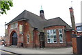
3
West Bridgford Community Hall
On the corner of Church Drive with Bridgford Road, this was built in 1929.
Image: © Kate Jewell
Taken: 22 Apr 2009
0.03 miles
4
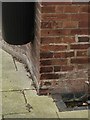
Lutterell Hall, Church Drive
There is an OS benchmark Image between the black litter bin and a white pipe, both right of the entrance doors
Image: © Roger Templeman
Taken: 12 May 2018
0.03 miles
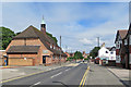
5
West Bridgford: building on Rectory Road
Flats are being built on the former ambulance station site. Nottinghamshire Police intend to leave the police station on the corner of Bridgford Road, so that site, too, will probably be redeveloped.
Image: © John Sutton
Taken: 14 Jul 2019
0.03 miles
6
Bench mark, Lutterell Hall, Church Street, West Bridgford
See http://www.geograph.org.uk/photo/5291061 for location.
Image: © Alan Murray-Rust
Taken: 20 Feb 2017
0.03 miles
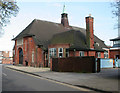
7
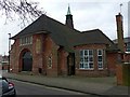
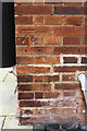
Lutterell Hall, Church Street, West Bridgford
Built in 1929 as the parish hall, now a public hall run by Rushcliffe Borough Council.
There is a bench mark http://www.geograph.org.uk/photo/5291058 on the return wall next to the litter bin.
Image: © Alan Murray-Rust
Taken: 20 Feb 2017
0.03 miles
8
Benchmark on Lutterell Hall, Church Drive
Ordnance Survey cut mark benchmark described on the Bench Mark Database at https://www.bench-marks.org.uk/bm82482
Image: © Roger Templeman
Taken: 12 May 2018
0.03 miles
9
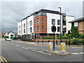
West Bridgford: new flats on Rectory Road
Bridgford Place is a block of one- and two-bedroom flats built on the site of the ambulance station. Image] shows the start of the work in 2018 Image] a later stage in 2019.
Image: © John Sutton
Taken: 6 Jul 2021
0.03 miles
10
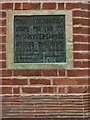
Lutterell Hall, Church Street, West Bridgford
Foundation stone. See http://www.geograph.org.uk/photo/5291061 for location, visible in the brickwork to the left of the entrance.
Image: © Alan Murray-Rust
Taken: 20 Feb 2017
0.04 miles