IMAGES TAKEN NEAR TO
Bridgford Road, NOTTINGHAM, NG2 6AT
Introduction
This page details the photographs taken nearby to Bridgford Road, NG2 6AT by members of the Geograph project.
The Geograph project started in 2005 with the aim of publishing, organising and preserving representative images for every square kilometre of Great Britain, Ireland and the Isle of Man.

There are currently over 7.5m images from over14,400 individuals and you can help contribute to the project by visiting https://www.geograph.org.uk
Image Map
Images are licensed for reuse under creativecommons.org/licenses/by-sa/2.0
Notes
- Clicking on the map will re-center to the selected point.
- The higher the marker number, the further away the image location is from the centre of the postcode.
Image Listing (237 Images Found)
Images are licensed for reuse under creativecommons.org/licenses/by-sa/2.0
Image
Details
Distance
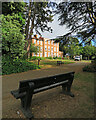
1

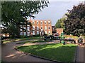
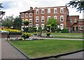
West Bridgford Hall
The Hall was built for the Musters family in 1768. In the 1920s it was acquired as offices by West Bridgford Urban District Council and the grounds became West Bridgford Park. After local government reorganisation in 1974 the Hall and park passed to Rushcliffe Borough Council. The ground floor remains the district's register office, but the upper floors have recently been converted to an "apart-hotel" (see Image]).
Image: © John Sutton
Taken: 25 Sep 2018
0.00 miles
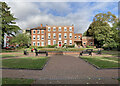
2
Bridgford Hall
Now used as a Registry Office https://www.rushcliffe.gov.uk/bridgfordhall/. It looks like a wedding had taken place just before this photo was taken
Image: © Philip Cornwall
Taken: 16 Oct 2021
0.00 miles
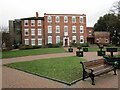
3
Bridgford Hall
The Hall was built for the Musters family in 1768. In the 1920s it was acquired as offices by West Bridgford Urban District Council and the grounds became West Bridgford Park. After local government reorganisation in 1974 the Hall and park passed to Rushcliffe Borough Council. The ground floor remains the district's register office, but the upper floors have been converted to an "apart-hotel" (see Image]).
Image: © John Sutton
Taken: 7 Sep 2022
0.00 miles
4
Bridgford Hall
Tye oldest paret dates from 1768 https://historicengland.org.uk/listing/the-list/list-entry/1045676?section=official-list-entry Now Council Offices.
Image: © Jonathan Thacker
Taken: 1 Jan 2023
0.00 miles
5
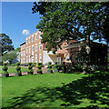
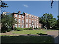
West Bridgford Hall
The house was built for the Musters family in 1774. It was later given to West Bridgford Urban District Council. Its grounds became Bridgford Park and the house the Council's offices. Later it became the Rushcliffe Register Office. Parts of it are now an "aparthotel".
Image: © John Sutton
Taken: 3 Jul 2019
0.01 miles
6
The Hall, West Bridgford
On a very frosty January lunch time.
See Image for historical information.
Image: © Kate Jewell
Taken: 4 Jan 2010
0.01 miles
7
West Bridgford Hall
The Hall, which stands in West Bridgford Park, dates from 1774. For nearly sixty years it was the offices of West Bridgford Urban District Council, and it is now the Register Office for the Rushcliffe district.
Image: © John Sutton
Taken: 20 May 2010
0.01 miles
8
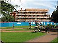
Restoration of West Bridgford Hall
The ground floor will continue to house Nottinghamshire County Council’s wedding and registration service. Upstairs there will be serviced flats for short-term stays.
Before local government reorganisation the Hall was the headquarters of West Bridgford Urban District Council.
Image: © John Sutton
Taken: 20 Jul 2016
0.01 miles
9
Bridgford Hall in West Bridgford
Now the local Registry Office.
Image: © Jeremy Bolwell
Taken: 18 Jul 2021
0.01 miles
10
West Bridgford Hall
The Hall was built for the Musters family in 1768. In the 1920s it was acquired as offices by West Bridgford Urban District Council and the grounds became West Bridgford Park. After local government reorganisation in 1974 the Hall and park passed to Rushcliffe Borough Council. The ground floor remains the district's register office, but the upper floors have been converted to an "apart-hotel" (see Image]).
Image: © John Sutton
Taken: 24 Sep 2021
0.01 miles