IMAGES TAKEN NEAR TO
Trent Bridge Buildings, NOTTINGHAM, NG2 5FB
Introduction
This page details the photographs taken nearby to Trent Bridge Buildings, NG2 5FB by members of the Geograph project.
The Geograph project started in 2005 with the aim of publishing, organising and preserving representative images for every square kilometre of Great Britain, Ireland and the Isle of Man.

There are currently over 7.5m images from over14,400 individuals and you can help contribute to the project by visiting https://www.geograph.org.uk
Image Map
Images are licensed for reuse under creativecommons.org/licenses/by-sa/2.0
Notes
- Clicking on the map will re-center to the selected point.
- The higher the marker number, the further away the image location is from the centre of the postcode.
Image Listing (788 Images Found)
Images are licensed for reuse under creativecommons.org/licenses/by-sa/2.0
Image
Details
Distance
1
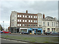
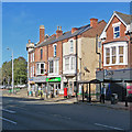
Trent Bridge Buildings
Art Deco lettable offices with retail premises, on the south side of Trent Bridge.
Image: © Alan Murray-Rust
Taken: 23 Sep 2008
0.01 miles
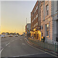
2
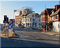
At the corner of Radcliffe Road
The Trent Bridge Inn is on the right in this picture taken from a pedestrian crossing at the end of Bridgford Road on a bright summer evening. In the background are the former Rushcliffe Council offices, which are being converted to flats to be called The Waterside Apartments.
Image: © John Sutton
Taken: 30 Jun 2019
0.01 miles
3
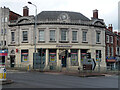
1 Radcliffe Road, Nottingham
Built as the National Provincial Bank by Walter Holden, c1926.
Ladbrokes has since gone.
Image: © Stephen Richards
Taken: 19 Jun 2015
0.01 miles
4
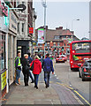
Forest fans on the way to the match
Nottingham Forest fans turning into Pavilion Road on their way to the Fulham game, which The Reds won 5-3. The Trent Bridge Inn is in the background, on the corner of Radcliffe Road.
Image: © John Sutton
Taken: 17 Sep 2014
0.02 miles
5
South of Trent Bridge on a summer evening
Looking towards the bridge from a pedestrian refuge at the corner of Radcliffe Road on a hot and cloudless June evening.
Image: © John Sutton
Taken: 13 Jun 2023
0.02 miles
6
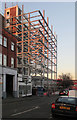
Steelwork on Pavilion Road
The former Rushcliffe Civic Centre (originally an hotel) is being converted to flats.
Image: © John Sutton
Taken: 26 Feb 2019
0.02 miles
7
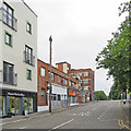
Pavilion Road
Looking towards where the A60 slopes down from Trent Bridge. Nottingham Forest football ground is behind the camera.
Image: © John Sutton
Taken: 27 Jun 2017
0.02 miles
8
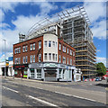
Trent House and Waterside Apartments
The distinctive curved building started life as an hotel, was for many years used as offices by Rushcliffe Borough Council and is now being converted to flats.
Image: © John Sutton
Taken: 30 Jun 2019
0.02 miles
9
The corner of Radcliffe Road
Newsagent, curry house and cafés opposite Trent Bridge Cricket Ground, photographed on a bright late-September morning.
Image: © John Sutton
Taken: 24 Sep 2018
0.02 miles
10
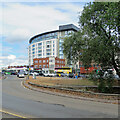
Waterside Apartments and traffic at Trent Bridge
Looking across part of the complicated junction of London Road and Radcliffe Road towards the Waterside Apartments, originally an hotel and for many years the headquarters of Rushcliffe District Council. A small section of the mediaeval Trent Bridge (the current one is Victorian and the river was wider in the Middle Ages) sits in the traffic island in the foreground.
Image: © John Sutton
Taken: 2 Aug 2022
0.02 miles