IMAGES TAKEN NEAR TO
Pierrepont Road, NOTTINGHAM, NG2 5DW
Introduction
This page details the photographs taken nearby to Pierrepont Road, NG2 5DW by members of the Geograph project.
The Geograph project started in 2005 with the aim of publishing, organising and preserving representative images for every square kilometre of Great Britain, Ireland and the Isle of Man.

There are currently over 7.5m images from over14,400 individuals and you can help contribute to the project by visiting https://www.geograph.org.uk
Image Map
Images are licensed for reuse under creativecommons.org/licenses/by-sa/2.0
Notes
- Clicking on the map will re-center to the selected point.
- The higher the marker number, the further away the image location is from the centre of the postcode.
Image Listing (90 Images Found)
Images are licensed for reuse under creativecommons.org/licenses/by-sa/2.0
Image
Details
Distance
1
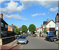
Pierrepont Road, Lady Bay
Looking towards the River Trent
Image: © Kate Jewell
Taken: 1 May 2008
0.06 miles
2
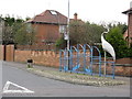
Bird Stop
A most unusual adjunct to a bus stop, found on Rutland Road, Nottingham.
Image: © Peter Whatley
Taken: 22 Mar 2009
0.08 miles
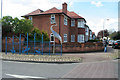
4
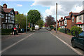
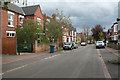
Pierrepont Road, Lady Bay
Suburban semis line the east side of Pierrepont Road in the Lady Bay area of West Bridgford. The origin of the Lady Bay name is obscure, one suggestion being that it refers to a bay mare that was once kept in fields here. The sign marking the way to the Poppy and Pint pub is also unusual - as is the pub itself (seeImage).
Image: © Stephen McKay
Taken: 18 Apr 2015
0.10 miles
5
Pierrepont Road, Lady Bay
Looking away from the River Trent.
Image: © Kate Jewell
Taken: 1 May 2008
0.11 miles
6
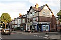
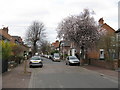
Lady Bay: chip shop and corner shop
The corner of Trent Boulevard and Pierrepont Road on a bright September evening.
Image: © John Sutton
Taken: 11 Sep 2012
0.12 miles
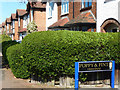
8
Spring Bank Holiday in Trent Boulevard
The corner of Pierrepont Road just after seven o'clock on the sunny evening of Bank Holiday Sunday.
Image: © John Sutton
Taken: 25 May 2014
0.12 miles
9
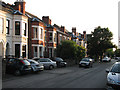
Rutland Road, Lady Bay
Lady Bay, although part of West Bridgford, is a distinct area between the A52 and the River Trent. Before it was built upon by the Victorians in the 19th century it was basically two very large fields and a wet marshy place by the river. Today it has its own personality, almost like a village. The main routes into the area are marked by these crane "gates" and there is a 20 mph speed limit throughout.
Image: © Kate Jewell
Taken: 1 May 2008
0.12 miles
10

Tower and dragon finial, Lady Bay Primary School
Arts & Crafts with Art Nouveau tendencies, and dating from c. 1900, the school tower makes a rather splendid sight against an evening sky. For a view of more of the building a few weeks later, see Image
Image: © John Sutton
Taken: 27 Apr 2011
0.12 miles