IMAGES TAKEN NEAR TO
Middlefield Road, SOUTHWELL, NG25 0XB
Introduction
This page details the photographs taken nearby to Middlefield Road, NG25 0XB by members of the Geograph project.
The Geograph project started in 2005 with the aim of publishing, organising and preserving representative images for every square kilometre of Great Britain, Ireland and the Isle of Man.

There are currently over 7.5m images from over14,400 individuals and you can help contribute to the project by visiting https://www.geograph.org.uk
Image Map
Images are licensed for reuse under creativecommons.org/licenses/by-sa/2.0
Notes
- Clicking on the map will re-center to the selected point.
- The higher the marker number, the further away the image location is from the centre of the postcode.
Image Listing (34 Images Found)
Images are licensed for reuse under creativecommons.org/licenses/by-sa/2.0
Image
Details
Distance
1
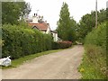
Poplar Farm, Morton
On Middlefield Road. No longer a working farm.
Image: © Alan Murray-Rust
Taken: 9 Aug 2020
0.01 miles
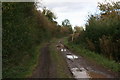
2
Annualhead Lane
Field access track, public bridleway between Morton and Southwell.
Image: © Alan Murray-Rust
Taken: 9 Aug 2020
0.11 miles
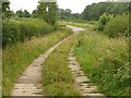
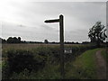
3
Track near Poplar Farm
The sign indicates that this track is also a public bridleway, which crosses the fields in the general direction of Southwell.
Image: © Richard Vince
Taken: 17 Apr 2014
0.11 miles
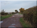
4
Middlefield Road, Morton
The name may well refer to one of the pre-enclosure field names. Farm track and public footpath.
Image: © Alan Murray-Rust
Taken: 9 Aug 2020
0.11 miles
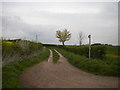
5
Middlefield Road meets New Road
Farm track and public footpath Middlefield Road joins onto New Road, which becomes Causeway Lane to the right.
Image: © Ajay Tegala
Taken: 29 Oct 2008
0.12 miles
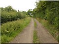
6
Middlefield Road, near Morton, and footpath to the railway
Image: © Chris
Taken: 19 Oct 2014
0.13 miles
7
Fingerpost to Morton
Not seen clearly on the photo a sign beside the post declares that further along the lane is private property
Image: © Tom Courtney
Taken: 7 Sep 2005
0.14 miles
8

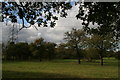
Pylons north of Morton
Definitely pylon country, presumably thanks to the proximity of Staythorpe power station.
Image: © Richard Vince
Taken: 17 Apr 2014
0.15 miles
9
Looks like an old orchard alongside the railway
South of Fiskerton Junction. It was a bit like the landscape you might see in Normandy, except that it lacked the mistletoe on the trees.
Image: © Chris
Taken: 19 Oct 2014
0.16 miles
10
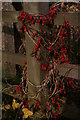
Decorated fence: garlands of bryony berries growing on the fence by the footpath across the railway
Image: © Chris
Taken: 19 Oct 2014
0.17 miles