IMAGES TAKEN NEAR TO
Manor Close, SOUTHWELL, NG25 0TG
Introduction
This page details the photographs taken nearby to Manor Close, NG25 0TG by members of the Geograph project.
The Geograph project started in 2005 with the aim of publishing, organising and preserving representative images for every square kilometre of Great Britain, Ireland and the Isle of Man.

There are currently over 7.5m images from over14,400 individuals and you can help contribute to the project by visiting https://www.geograph.org.uk
Image Map
Images are licensed for reuse under creativecommons.org/licenses/by-sa/2.0
Notes
- Clicking on the map will re-center to the selected point.
- The higher the marker number, the further away the image location is from the centre of the postcode.
Image Listing (105 Images Found)
Images are licensed for reuse under creativecommons.org/licenses/by-sa/2.0
Image
Details
Distance
1
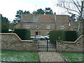
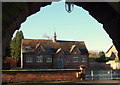
The Manor House
18th Century house with a later extension in the same style.
Image: © Alan Murray-Rust
Taken: 18 Dec 2009
0.04 miles
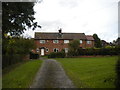
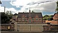
5
The old school
Built in 1874 and close in 1983 because it no longer met appropriate standards for a local authority school, it has found further life as the Kindergarten and Pre-Prep department of a local Preparatory School.
Image: © Alan Murray-Rust
Taken: 18 Dec 2009
0.07 miles
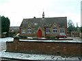
7
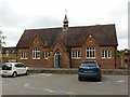
The old village school, Oxton
Built in 1870 http://www.geograph.org.uk/photo/6542944 , it closed as a village primary school in 1984, although it has since been used as a reception class annexe to a private junior school based in Calverton.
Image: © Alan Murray-Rust
Taken: 16 Jul 2020
0.08 miles
8
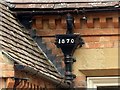
The old village school, Oxton
Rainwater hopper dated 1870. See http://www.geograph.org.uk/photo/6542943 for location.
Image: © Alan Murray-Rust
Taken: 16 Jul 2020
0.08 miles
9
School, Main St, Oxton, Notts.
This school opposite the church was built by public subscription in 1870 and it continued educating local children for more a hundred years until it was forced to close in 1984. Even By 1978 £3,000 was needed for renovations to its fabric. No support for its continued use as a school had come from the church; furthermore the church's future role in it was being questioned. Fortunately for local families however, the case for its retention as a village school was successfully made in that same year. Following its later closure however, by the Nottinghamshire Education Authority, the school was reopened as a private school called Salterford House Kindergarten and Pre-Prep School.
Image: © David Hallam-Jones
Taken: 4 Jan 2015
0.08 miles
10
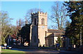
Main Street, Oxton, Notts.
The Grade I-listed Parish Church of St Peter & St Paul is seen here from Manor Close. It is generally thought that a church existed at Oxton at the time of the Domesday survey although it has been suggested that it would probably have been smaller and probably aisle-less. As an adult, the son of the Rev. William Mompesson of Eyam Plague fame became a prebendary of Oxton and Crophill. As an infant his son was evacuated to Sheffield in 1666, prior to the plague taking hold of that village. This occurred before the quarantine was agreed, after which time all the Eyam villagers were pressured into staying put.
Image: © David Hallam-Jones
Taken: 4 Jan 2015
0.08 miles