IMAGES TAKEN NEAR TO
New Road, SOUTHWELL, NG25 0SL
Introduction
This page details the photographs taken nearby to New Road, NG25 0SL by members of the Geograph project.
The Geograph project started in 2005 with the aim of publishing, organising and preserving representative images for every square kilometre of Great Britain, Ireland and the Isle of Man.

There are currently over 7.5m images from over14,400 individuals and you can help contribute to the project by visiting https://www.geograph.org.uk
Image Map
Images are licensed for reuse under creativecommons.org/licenses/by-sa/2.0
Notes
- Clicking on the map will re-center to the selected point.
- The higher the marker number, the further away the image location is from the centre of the postcode.
Image Listing (92 Images Found)
Images are licensed for reuse under creativecommons.org/licenses/by-sa/2.0
Image
Details
Distance
1
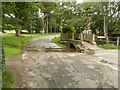
Ford on New Road, Oxton
Crossing the Oxton Beck. Placid at the moment, but flash floods are not unknown.
Image: © Alan Murray-Rust
Taken: 16 Jul 2020
0.03 miles
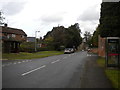
2
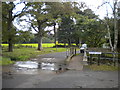
Ford and footbridge, Oxton
Where New Road (left foreground) becomes Sandy Lane, at the end of the appropriately named Water Lane.
Image: © Richard Vince
Taken: 9 Oct 2014
0.03 miles
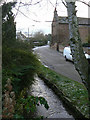
3
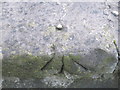
Ordnance Survey Rivet Cut Mark
This can be found on the footbridge at the ford in Sandy Lane.
For more detail see : http://www.bench-marks.org.uk/bm45929
Image: © Peter Wood
Taken: 17 Oct 2012
0.03 miles
4
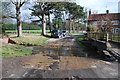
Oxton Ford
This ford is found in Sandy Lane and the beck fed from the mill pond then flows beside Water Lane.
Image: © John Walton
Taken: 26 Feb 2012
0.03 miles
5
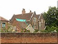
Church Farmhouse, Oxton
Late 17th century with later additions, currently undergoing renovation. Listed Grade II.
Image: © Alan Murray-Rust
Taken: 16 Jul 2020
0.04 miles
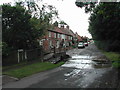
6
Water Lane
Running alongside the Oxton Beck, quite docile when this view was taken.
Image: © Alan Murray-Rust
Taken: 18 Dec 2009
0.04 miles
8
Oxton Ford
Due to the low temperatures there was a considerable accumulation of ice on the road on the exits from the ford. The beck is at quite low levels for this time of year.
Image: © Alan Murray-Rust
Taken: 18 Dec 2009
0.04 miles
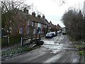
10
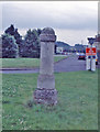
Old Milestone (new)
Location not identified.
by the B6386, in parish of Oxton (Newark And Sherwood District), opp. Main Street and Water Lane, by the road.
Surveyed
Milestone Society National ID: NT_OXTMM
Image: © Milestone Society
Taken: Unknown
0.06 miles