IMAGES TAKEN NEAR TO
Ollerton Road, SOUTHWELL, NG25 0RE
Introduction
This page details the photographs taken nearby to Ollerton Road, NG25 0RE by members of the Geograph project.
The Geograph project started in 2005 with the aim of publishing, organising and preserving representative images for every square kilometre of Great Britain, Ireland and the Isle of Man.

There are currently over 7.5m images from over14,400 individuals and you can help contribute to the project by visiting https://www.geograph.org.uk
Image Map
Images are licensed for reuse under creativecommons.org/licenses/by-sa/2.0
Notes
- Clicking on the map will re-center to the selected point.
- The higher the marker number, the further away the image location is from the centre of the postcode.
Image Listing (5 Images Found)
Images are licensed for reuse under creativecommons.org/licenses/by-sa/2.0
Image
Details
Distance
1
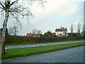
Moorfields Farm
Moorfields Farm seen across the A6097 Ollerton Road.
Image: © Antony Dixon
Taken: 8 Jan 2016
0.04 miles
2
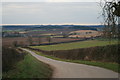
Moorfield Farm, Mound
Grassy hill in the middle-distance is listed on some maps. Typical of a burial mound, it may be related to the Saxon site of Robin Hood Hill.
Image: © Martin Jones
Taken: 3 Jan 2009
0.15 miles
3

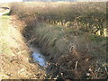
Junction Ollerton Road ( A6097 )/Greaves Lane
Image: © Tom Courtney
Taken: 23 Aug 2005
0.21 miles
5
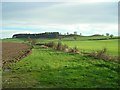
Fields next to Robin Hood Hill
View across the fields through a gap in the hedge beside the A6097 Ollerton Road, looking towards Robin Hood Hill. The mound on the right is thought to be a burial mound, the ones to its left appear to be natural.
Image: © Antony Dixon
Taken: 8 Jan 2016
0.25 miles