IMAGES TAKEN NEAR TO
Nottingham Road, SOUTHWELL, NG25 0QW
Introduction
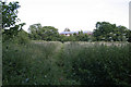
This page details the photographs taken nearby to Nottingham Road, NG25 0QW by members of the Geograph project.
The Geograph project started in 2005 with the aim of publishing, organising and preserving representative images for every square kilometre of Great Britain, Ireland and the Isle of Man.

There are currently over 7.5m images from over14,400 individuals and you can help contribute to the project by visiting https://www.geograph.org.uk
Image Map
Images are licensed for reuse under creativecommons.org/licenses/by-sa/2.0
Notes
- Clicking on the map will re-center to the selected point.
- The higher the marker number, the further away the image location is from the centre of the postcode.
Image Listing (37 Images Found)
Images are licensed for reuse under creativecommons.org/licenses/by-sa/2.0
Image
Details
Distance
1
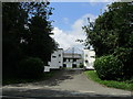
Entrance to Springfield House, Nottingham Road
Image: © Jonathan Thacker
Taken: 1 Aug 2019
0.01 miles
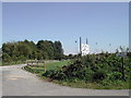
3
Grounds of Southwell RFC
Recreating this 'First' for the square https://www.geograph.org.uk/photo/40852 .
This is now the back way into the new Leisure Centre (buildings to the left) and a new long stay car park for the town.
Image: © Alan Murray-Rust
Taken: 20 Sep 2021
0.11 miles
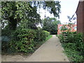
4
Footpath at the back of Halloughton Road
This path doglegs between a series of gardens; it seems that its original course has been modified as development has taken place. It leads through to Nottingham Road near the Minster School.
Image: © Alan Murray-Rust
Taken: 19 Jun 2008
0.11 miles
5
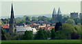
Southwell NG25, Notts.
The Westgate quarter of Southwell between Holy Trinity Church and Southwell Minster seen from a farm track that starts and/or terminates near Halloughton Road, Southwell. This arable land is part of the Brackenhurst Estate at the side of the A612 (the Southwell- Nottingham Road). The estate covers 200 hectares and comprises of Home Farm, an equestrian Centre, an animal care unit, a horticultural teaching and research centre and a veterinary nursing unit. It has been used and managed by Nottingham Trent University since 1999 and is now known as the School of Animal, Rural and Environmental Sciences. The land on the estate was bought by a Reverend Thomas Coats Cane in 1827 and he built Brackenhurst Hall within the estate in 1828. His successor was William Norton Hicking, a successful Nottingham lace industry businessman. Hicking became a County Councillor and was created a Baronet in 1918. He died in 1947 and the estate was sold to Nottinghamshire County Council who opened it as a Farm Institute in 1949.
Image: © David Hallam-Jones
Taken: 19 May 2013
0.11 miles
6
Footpath from Westhorpe
The hedge at the back marks the line of Nottingham Road, with one of the Minster School buildings beyond it.
Image: © Alan Murray-Rust
Taken: 19 Jun 2008
0.13 miles
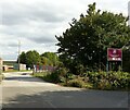
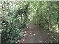
7
Footpath to Westgate
Skirts a new housing development.
Image: © Jonathan Thacker
Taken: 1 Aug 2019
0.15 miles
8
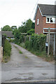
Access to 35, 35A, 37 and 39A Halloughton Road
This is also a public footpath, clearly of long standing; its continuation off this driveway is however far from obvious and took me some time to find.
Image: © Alan Murray-Rust
Taken: 19 Jun 2008
0.15 miles
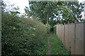
9
Footpath to Nottingham Road
On the left is a steep drop down to a small stream.
Image: © Jonathan Thacker
Taken: 1 Aug 2019
0.15 miles
10
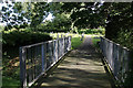
Holy Trinity graveyard
The graveyard clearly originally stopped at the stream, but has been extended later. Amodern bridge provides access across the Potwell Dyke.
Image: © Alan Murray-Rust
Taken: 19 Jun 2008
0.15 miles