IMAGES TAKEN NEAR TO
Gables Drive, SOUTHWELL, NG25 0QU
Introduction
This page details the photographs taken nearby to Gables Drive, NG25 0QU by members of the Geograph project.
The Geograph project started in 2005 with the aim of publishing, organising and preserving representative images for every square kilometre of Great Britain, Ireland and the Isle of Man.

There are currently over 7.5m images from over14,400 individuals and you can help contribute to the project by visiting https://www.geograph.org.uk
Image Map
Images are licensed for reuse under creativecommons.org/licenses/by-sa/2.0
Notes
- Clicking on the map will re-center to the selected point.
- The higher the marker number, the further away the image location is from the centre of the postcode.
Image Listing (28 Images Found)
Images are licensed for reuse under creativecommons.org/licenses/by-sa/2.0
Image
Details
Distance
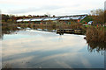
1
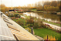
Hockerton Housing Project
Lake-facing fronts of the 5 eco-homes at Hockerton Housing Project
Image: © Richard Croft
Taken: 17 Nov 2012
0.01 miles
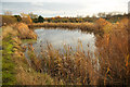
2
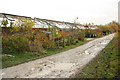
Reed bed
Sewage treatment reed bed at Hockerton Housing Project. The liquid outflow from septic tanks passes through the bed of bulrush and common reed which provide oxygen for aerobic bacteria to digest the bacteria before clean, nutrient-rich water flows in to the lake http://www.geograph.org.uk/photo/3230778
Image: © Richard Croft
Taken: 17 Nov 2012
0.02 miles
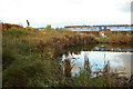
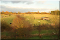
3
Mystery Hill Lake
Lake at Hockerton Housing Project for a variety of purposes including recreational use, Carp fish-farming and sewage treatment reed bed, the five low-carbon, energy-efficient homes are on the opposite bank.
Image: © Richard Croft
Taken: 17 Nov 2012
0.03 miles
4
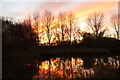
Mystery Hill Lake
Sunset and Mystery Hill Lake at Hockerton Housing Project
Image: © Richard Croft
Taken: 17 Nov 2012
0.05 miles
5
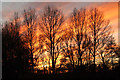
Hockerton Sunset
Sunset from Mystery Hill Lake http://www.geograph.org.uk/photo/3230817 at Hockerton Housing Project
Image: © Richard Croft
Taken: 17 Nov 2012
0.05 miles
6
Hockerton Housing Project
Solar PV panels, SSW facing conservatory glazed roofs and gardens facing the lake at Hockerton Housing Project
Image: © Richard Croft
Taken: 17 Nov 2012
0.05 miles
7
Mystery Hill
View from the earth bank covering Hockerton Housing Project to the site of the medieval village of Hockerton, marked by the seven standing stones http://www.geograph.org.uk/photo/3230730 in the centre
Image: © Richard Croft
Taken: 17 Nov 2012
0.06 miles
8
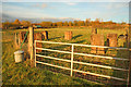
Seven standing stones
Seven two-ton standing stones placed here by the Hockerton Housing Project community in 2000 marking the site of the 'turning yard' of the medieval village of Hockerton
Image: © Richard Croft
Taken: 17 Nov 2012
0.08 miles
9
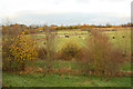
Mystery Hill
View to Mystery Hill and the A617 beyond the hedgerow from the top of the earth bank covering Hockerton Housing Project
Image: © Richard Croft
Taken: 17 Nov 2012
0.09 miles
10
The Reservoir
Water source of non-potable water for Hockerton Housing Project
Image: © Richard Croft
Taken: 17 Nov 2012
0.10 miles