IMAGES TAKEN NEAR TO
Upton Road, SOUTHWELL, NG25 0QD
Introduction
This page details the photographs taken nearby to Upton Road, NG25 0QD by members of the Geograph project.
The Geograph project started in 2005 with the aim of publishing, organising and preserving representative images for every square kilometre of Great Britain, Ireland and the Isle of Man.

There are currently over 7.5m images from over14,400 individuals and you can help contribute to the project by visiting https://www.geograph.org.uk
Image Map
Images are licensed for reuse under creativecommons.org/licenses/by-sa/2.0
Notes
- Clicking on the map will re-center to the selected point.
- The higher the marker number, the further away the image location is from the centre of the postcode.
Image Listing (106 Images Found)
Images are licensed for reuse under creativecommons.org/licenses/by-sa/2.0
Image
Details
Distance
1
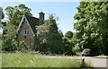
Gate Cottage
Not a lodge to an estate, but a level crossing keeper's cottage on the old Southwell railway branch, hence the name.
Image: © Alan Murray-Rust
Taken: 9 Jun 2008
0.00 miles
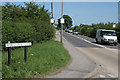
2
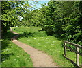
Southwell NG25, Notts.
The Upton Road access point into the Community Orchard. Behind the photographer is a gate opening onto a road bridge that that carries Upton Road (the A612 South-Upton road) across the River Greet, near to the National Trust former workhouse. The orchard hosts a collection of apple tree saplings, of different types, in a riverside setting. A five minute stroll directly ahead brings walkers to the former Cauldwell's Mill where Station Road becomes Normanton Road.
Image: © David Hallam-Jones
Taken: 25 May 2013
0.00 miles
3
Southwell NG25, Notts.
An access gate into the Southwell Community Orchard and also onto a footpath that forms part of several trails, including the Easthorpe trail, the Bramley Apple trail and the Southwell trail. The gate lies between this private house and Greet Bridge (that carries the road over the River Greet) alongside Upton Road (the A612 Southwell-Upton road); the centre of Southwell being to the left. Apparently this property was a level crossing gate-keeper’s cottage. A short branch line was opened from Rolleston Junction to Southwell in 1847. This was also connected by the Midland Railway Company to a line from Mansfield. However, the stretch between Southwell and Mansfield was closed to passengers in 1929 leaving a short branch from Rolleston until closure in 1959. See also SK7154 : Gate Cottage.
Image: © David Hallam-Jones
Taken: 25 May 2013
0.01 miles
4
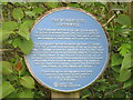
Plaque to Southwell Workhouse
Located to left of roadside pedestrian gate to Workhouse.
Image: © El Loco
Taken: 6 May 2021
0.03 miles
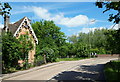
5
Greet Bridge, Upton Road
Upton Road bends sharply as it crosses the river. There was previously also a level crossing just this side of the bridge
Image: © Alan Murray-Rust
Taken: 9 Jun 2008
0.03 miles
6

You can't have one without the other
Historic buildings open to the public cannot survive in today's age without provision for the car-borne visitor.
Image: © Alan Murray-Rust
Taken: 21 Apr 2013
0.05 miles
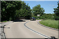
7
Upton Road at Workhouse Lane
The main road from Nottingham to Newark north of the River Trent.
Image: © Alan Murray-Rust
Taken: 9 Jun 2008
0.06 miles
8
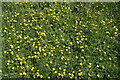
A host of golden . . .
. . . buttercups (not Daffodils of course).
On the Southwell Trail.
Image: © Alan Murray-Rust
Taken: 9 Jun 2008
0.06 miles
9
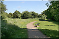
Robin Hood Way near Easthorpe
At this point the Robin Hood Way is combined with the Southwell Trail
Image: © Alan Murray-Rust
Taken: 9 Jun 2008
0.06 miles
10
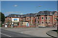
Southwell Court Care Centre
"Luxury Care Home". The architect has clearly drawn inspiration from the nearby Image
Image: © Alan Murray-Rust
Taken: 9 Jun 2008
0.06 miles