IMAGES TAKEN NEAR TO
Normanton, SOUTHWELL, NG25 0PS
Introduction
This page details the photographs taken nearby to NG25 0PS by members of the Geograph project.
The Geograph project started in 2005 with the aim of publishing, organising and preserving representative images for every square kilometre of Great Britain, Ireland and the Isle of Man.

There are currently over 7.5m images from over14,400 individuals and you can help contribute to the project by visiting https://www.geograph.org.uk
Image Map
Images are licensed for reuse under creativecommons.org/licenses/by-sa/2.0
Notes
- Clicking on the map will re-center to the selected point.
- The higher the marker number, the further away the image location is from the centre of the postcode.
Image Listing (58 Images Found)
Images are licensed for reuse under creativecommons.org/licenses/by-sa/2.0
Image
Details
Distance
1
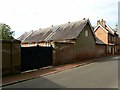
Coach house at Normanton Hall
Built at the same time as the house, c.1870, Listed Grade II together with the stable range http://www.geograph.org.uk/photo/6604840 . Both buildings have been converted for residential use as holiday lets.
Image: © Alan Murray-Rust
Taken: 13 Sep 2020
0.01 miles
2
Stable range at Normanton Hall
Built at the same time as the house, c.1870, Listed Grade II together with the coach house http://www.geograph.org.uk/photo/6604844
Image: © Alan Murray-Rust
Taken: 13 Sep 2020
0.01 miles
4

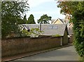
Normanton Hall, Southwell
Victorian country House in distinctive yellow brick, built c.1870 incorporating parts of an earlier building. Listed Grade II. The impressive cast iron gates are a 21st century addition.
Image: © Alan Murray-Rust
Taken: 13 Sep 2020
0.03 miles
5
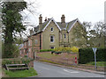
Normanton Hall
Typical Victorian large house for an affluent local person. Dating from around 1870, in gothic-revival style. Listed Grade II, as are the garden wall and the wall on this side of the road. The latter has a bench mark http://www.geograph.org.uk/photo/3429595 on the corner. The postbox is illustrated here http://www.geograph.org.uk/photo/3429601.
Image: © Alan Murray-Rust
Taken: 21 Apr 2013
0.03 miles
6
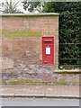
Normanton/Southwell postbox, NG25 94
GVIR wall box in the garden wall of Normanton Hall http://www.geograph.org.uk/photo/3429542.
Image: © Alan Murray-Rust
Taken: 21 Apr 2013
0.05 miles
7
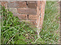
Bench Mark, Normanton crossroads
See http://www.geograph.org.uk/photo/3429542 for the location view.
Image: © Alan Murray-Rust
Taken: 21 Apr 2013
0.05 miles
8
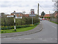
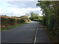
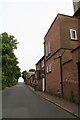
Normanton crossroads
Looking into the hamlet. The fingerpost is a traditional Notts County Council cast-iron example with top ring and four fingers.
Image: © Alan Murray-Rust
Taken: 21 Apr 2013
0.08 miles