IMAGES TAKEN NEAR TO
Warrands Close, SOUTHWELL, NG25 0NT
Introduction
This page details the photographs taken nearby to Warrands Close, NG25 0NT by members of the Geograph project.
The Geograph project started in 2005 with the aim of publishing, organising and preserving representative images for every square kilometre of Great Britain, Ireland and the Isle of Man.

There are currently over 7.5m images from over14,400 individuals and you can help contribute to the project by visiting https://www.geograph.org.uk
Image Map
Images are licensed for reuse under creativecommons.org/licenses/by-sa/2.0
Notes
- Clicking on the map will re-center to the selected point.
- The higher the marker number, the further away the image location is from the centre of the postcode.
Image Listing (81 Images Found)
Images are licensed for reuse under creativecommons.org/licenses/by-sa/2.0
Image
Details
Distance
1
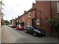
Eighteenth century cottages in Westhorpe, Southwell
Image: © Jonathan Thacker
Taken: 1 Aug 2019
0.02 miles
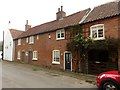
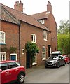
2
27 Westhorpe, Southwell
A pair of late 18th century cottages merged into a single dwelling, Listed Grade II together with no.29 to the right..
Image: © Alan Murray-Rust
Taken: 26 Jul 2020
0.02 miles
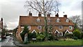
3
29 & 27 Westhorpe, Southwell
A row of originally 3, now 2, cottages, late 18th century, Listed Grade II.
Image: © Alan Murray-Rust
Taken: 26 Jul 2020
0.02 miles
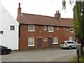
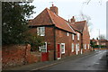
5
33 Westhorpe, Southwell
Early 19th century cottage, Listed Grade II.
Image: © Alan Murray-Rust
Taken: 26 Jul 2020
0.03 miles
6
Westhorpe cottages
Westhorpe became a Conservation Area in 1971 because of its unique cottages and farmsteads, long brick walls, mature trees and attractive surroundings.
Image: © Graham Hogg
Taken: 19 Jan 2015
0.03 miles
7
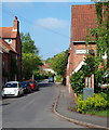
Westhorpe, Southwell NG25, Notts.
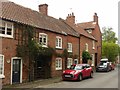
With the former Market Place behind the photographer - now simply a crossroads created by the convergence of four roads, one of which is the B6386 from Southwell, this is the view along one of Westhorpe's main thoroughfares, called "Westhorpe". Sunnyside Cottages (a terrace of 3-4) are all that remain of sixteen back-to-back properties that are said to have been used as dwellings and places of work by "stockingers" (stocking frame operators) during the late C16th. In addition, parallel with the red car, is a property formerly called The Workman’s Rest (sic). In the C19th a Mrs Warrand of Westhorpe Hall set up ‘The Rest’ as an institute for leisure purposes, personal education and religious meetings. A large upper room was also used by the local women, led by the wife of the Vicar of Holy Trinity Church, for sewing garments for needy children. In the early C20th it was used as a sub-post office.
Image: © David Hallam-Jones
Taken: 19 May 2013
0.03 miles
8
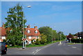
Westhorpe, Southwell NG25, Notts.
Four roads converge here at the point formerly known as the Market Place. Vehicles on this, "the Oxton Road" (the B6386), can continue ahead and join the A6097 (the Epperstone By-Pass) a few miles ahead. The centre of Southwell lies a 4-5 minute drive away behind the photographer. The row of cottages behind the tall tree are all that remain of sixteen back-to-back properties that are said to have been used as dwellings and places of work by "stockingers" (stocking frame operators) during the late C16th.
Image: © David Hallam-Jones
Taken: 19 May 2013
0.03 miles
9
31 Westhorpe, Southwell
A pair of late 18th century cottages merged into a single dwelling, Listed Grade II.
Image: © Alan Murray-Rust
Taken: 26 Jul 2020
0.03 miles
10
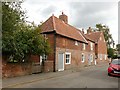
28 & 24 Westhorpe, Southwell
Originally 3 cottages, mid 17th century, later converted to 2, with other later alterations, Listed Grade II.
Image: © Alan Murray-Rust
Taken: 26 Jul 2020
0.03 miles