IMAGES TAKEN NEAR TO
Allenby Road, SOUTHWELL, NG25 0NL
Introduction
This page details the photographs taken nearby to Allenby Road, NG25 0NL by members of the Geograph project.
The Geograph project started in 2005 with the aim of publishing, organising and preserving representative images for every square kilometre of Great Britain, Ireland and the Isle of Man.

There are currently over 7.5m images from over14,400 individuals and you can help contribute to the project by visiting https://www.geograph.org.uk
Image Map
Images are licensed for reuse under creativecommons.org/licenses/by-sa/2.0
Notes
- Clicking on the map will re-center to the selected point.
- The higher the marker number, the further away the image location is from the centre of the postcode.
Image Listing (77 Images Found)
Images are licensed for reuse under creativecommons.org/licenses/by-sa/2.0
Image
Details
Distance
3
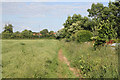
Footpath along the rape field
The rape crop is showing signs of being heavy enough to collapse the crop
Image: © Alan Murray-Rust
Taken: 19 Jun 2008
0.05 miles
4
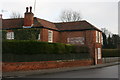
Sunnyside Cottages, Westhorpe
Grade II listed: http://www.britishlistedbuildings.co.uk/en-242522-sunnyside-southwell-nottinghamshire
Terrace of 5 cottages, now 4 dwellings. Early C19, with mid
C19 alterations. This fine terrace originally was 16 back to back cottages but
conversions and road widening have reduced its number. Some of these
cottages would have been used by Framework Knitters, Stockingers. The
stocking frame was invented in Calverton in the 1580’s. Only effective
local action in the 1970’s stopped some of these cottages from being
demolished. Richard Fisher, who grew up in Westhorpe in the late 19th
century noted in his ‘Memories’ ‘that a parson complained that the
stockingers of Westhorpe got more money per week than he did and it
caused much drunkenness there’. Fisher continues ‘Before the coming of
steam power men used to work the machines and the women seamed by
hand. The stockings were carried to Nottingham to be worsted……in
summer when there was little trade they worked on the land labouring’
Some cottages had an extra window light added so they could work
longer hours. See: http://web.archive.org/web/20150714070650/http://www.southwellcouncil.com/files/Heritage%20Trails/Westhorpe3.pdf.
I have been sent the following information about one of the cottages: "...my grandfather's name was William Hall, my grandmother's name Mary Hall born 1844. According to the 1891 census lived at No 14 Post Office which I was told was the end cottage. They had eight children including my mother Alice. I can't imagine where they would sleep that lot if it was a back to back cottage! how things have changed". He adds that Alice Hall's mother is believed to have been the sub-postmistress. Any further information would be welcomed.
Image shows the building which was used as the sub-postoffice, though it states this was in the early 20th Century.
Image: © Chris
Taken: 29 Dec 2013
0.06 miles
5
Ghost sign on building in Westhorpe
The building is now an antique shop and was formerly the Grapes Inn. There are at least two generations of lettering on this faded painted sign. One may read 'DAVY'S NEWARK ALES' (1830-1975).
Image: © Graham Hogg
Taken: 19 Jan 2015
0.06 miles
6
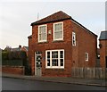
Antique shop in Westhorpe
A blue plaque states that this was the site of the Grapes Inn 1830-1975
Image: © Graham Hogg
Taken: 19 Jan 2015
0.06 miles
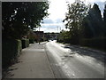
7
Oxton Road
This is the edge of the built up area Oxton Road is the B6386 to Oxton and Calverton
Image: © Alan Murray-Rust
Taken: 19 Jun 2008
0.07 miles
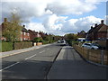
8
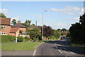
Westhorpe, Southwell NG25, Notts.
The boundary between this suburb and the Westgate area, both part of Southwell, is formed by an imaginary line across the road ahead, near the pillar box. The red car is parked outside of what is currently an “Antiques” shop, although it was known as “The Grapes Inn” between 1830-1975. Southwell lies a 3-4 minute drive ahead on this, the B6386.
Image: © David Hallam-Jones
Taken: 19 May 2013
0.07 miles
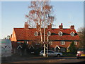
9
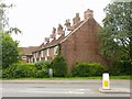
Sunnyside, Westhorpe, Southwell
A group of 4, formerly 5, cottages, early 19th century with mid 19th century alterations. Listed Grade II. There were originally two further cottages at this end of the range.
Image: © Alan Murray-Rust
Taken: 26 Jul 2020
0.07 miles
10
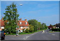
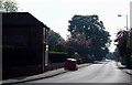
Westhorpe, Southwell NG25, Notts.
Four roads converge here at the point formerly known as the Market Place. Vehicles on this, "the Oxton Road" (the B6386), can continue ahead and join the A6097 (the Epperstone By-Pass) a few miles ahead. The centre of Southwell lies a 4-5 minute drive away behind the photographer. The row of cottages behind the tall tree are all that remain of sixteen back-to-back properties that are said to have been used as dwellings and places of work by "stockingers" (stocking frame operators) during the late C16th.
Image: © David Hallam-Jones
Taken: 19 May 2013
0.08 miles