IMAGES TAKEN NEAR TO
Westgate, SOUTHWELL, NG25 0LT
Introduction
This page details the photographs taken nearby to Westgate, NG25 0LT by members of the Geograph project.
The Geograph project started in 2005 with the aim of publishing, organising and preserving representative images for every square kilometre of Great Britain, Ireland and the Isle of Man.

There are currently over 7.5m images from over14,400 individuals and you can help contribute to the project by visiting https://www.geograph.org.uk
Image Map
Images are licensed for reuse under creativecommons.org/licenses/by-sa/2.0
Notes
- Clicking on the map will re-center to the selected point.
- The higher the marker number, the further away the image location is from the centre of the postcode.
Image Listing (96 Images Found)
Images are licensed for reuse under creativecommons.org/licenses/by-sa/2.0
Image
Details
Distance
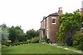
1
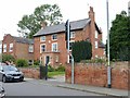
102 Westgate, Southwell - Honing House
Late 18th century house with top floor added in the early 19th and later additions, Listed Grade II.
The garden wall and gate are separately Listed Grade II.
Image: © Alan Murray-Rust
Taken: 30 Aug 2020
0.05 miles
2
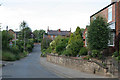
Halloughton Road
This forms a cut through from Nottingham Road to Westhorpe
Image: © Alan Murray-Rust
Taken: 19 Jun 2008
0.05 miles
3

Bee Orchid
Found on one of my recent outings. The exact location is not given.
Image: © Alan Murray-Rust
Taken: 19 Jun 2008
0.09 miles
4
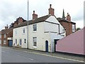
81A Westgate, Southwell
Late 18th century, extended away from the road – the plain brick section behind - in 1824 http://www.geograph.org.uk/photo/6587206 , subsequently split to form two houses, Listed Grade II as a single Listing.
Image: © Alan Murray-Rust
Taken: 30 Aug 2020
0.09 miles
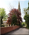
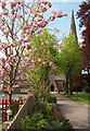
5
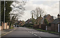
Westgate, Southwell
Holy Trinity church spire can be seen ahead.
Image: © J.Hannan-Briggs
Taken: 30 Jan 2016
0.09 miles
6
81 Westgate, Southwell
The early 19th century extension of no.81A http://www.geograph.org.uk/photo/6587203 , dated 1824. Regency style, Listed Grade II.
Image: © Alan Murray-Rust
Taken: 30 Aug 2020
0.09 miles
7
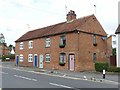
84-90 Westgate, Southwell
A row of early 19th century cottages. The nearest, no.84, features cast-iron Gothick windows and is Listed Grade II.
Image: © Alan Murray-Rust
Taken: 30 Aug 2020
0.10 miles
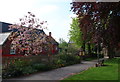
8
Southwell NG25, Notts.
A private track, off Westgate, on the east side of Holy Trinity Church, leading to two or three houses.
Image: © David Hallam-Jones
Taken: 19 May 2013
0.11 miles
9
Southwell NG25, Notts.
The footpath between Westgate and Holy Trinity Church. Westgate is the principal road between the centre of Southwell and the suburb of Westhorpe. On the other side of the boundary fence on the left is Holy Trinity Church of England Infants' School.
Image: © David Hallam-Jones
Taken: 19 May 2013
0.12 miles
10
Southwell NG25, Notts.
Holy Trinity church at the end of a footpath that begins on Westgate, immediately behind the photographer. Westgate being the principal road between the centre of Southwell and the suburb of Westhorpe. The boundary fence on the left encloses the playground of Holy Trinity Church of England Infants' School.
Image: © David Hallam-Jones
Taken: 19 May 2013
0.12 miles