IMAGES TAKEN NEAR TO
Trinity Place, SOUTHWELL, NG25 0LE
Introduction
This page details the photographs taken nearby to Trinity Place, NG25 0LE by members of the Geograph project.
The Geograph project started in 2005 with the aim of publishing, organising and preserving representative images for every square kilometre of Great Britain, Ireland and the Isle of Man.

There are currently over 7.5m images from over14,400 individuals and you can help contribute to the project by visiting https://www.geograph.org.uk
Image Map
Images are licensed for reuse under creativecommons.org/licenses/by-sa/2.0
Notes
- Clicking on the map will re-center to the selected point.
- The higher the marker number, the further away the image location is from the centre of the postcode.
Image Listing (154 Images Found)
Images are licensed for reuse under creativecommons.org/licenses/by-sa/2.0
Image
Details
Distance
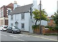
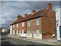
1
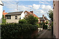
Trinity Place
A narrow lane leading off Westgate. The prominent white building is a fine example of an outworkers workshop, probably related to the textile trade. Outworkers would normally carry out specialised finishing operations.
Image: © Alan Murray-Rust
Taken: 19 Jun 2008
0.00 miles
2
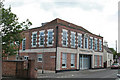
The Old Cinema
A fine mock-Georgian facade for this Georgian town. Now converted to apartments. The old name IDEAL can be picked out in metal letters between the first floor windows.
Image: © Alan Murray-Rust
Taken: 19 Jun 2008
0.02 miles
3
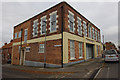
The Old Cinema
A closer view than Image, taken in 2008. The only obvious changes are some repainting.
Image: © Ian Taylor
Taken: 27 Oct 2014
0.03 miles
4
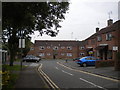
Coghill Court, Southwell
A residential cul de sac off Westgate.
Image: © Richard Vince
Taken: 31 May 2014
0.03 miles
5
55 Westgate, Southwell
Late 18th century house, rendered and whitewashed, with probably later slate roof, Listed Grade II.
Image: © Alan Murray-Rust
Taken: 30 Aug 2020
0.03 miles
6
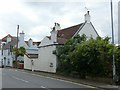
57 Westgate, Southwell ? Trinity House
Mid 18th century house, with later alterations, Listed Grade II. Like other houses on the south side of Westgate, it faces away from the road.
Image: © Alan Murray-Rust
Taken: 30 Aug 2020
0.04 miles
7
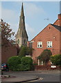
Southwell NG25, Notts.
Holy Trinity Church seen from Westgate. This side road - a cul-de-sac - and the residential accommodation for elderly people that occupies the corner site, are both known as Coghill Court. They were named after Canon E.A. Coghill (1890-1941). It was the Rev. Coghill who finally abolished pew rents in 1907, making the church "free and open".
Image: © David Hallam-Jones
Taken: 19 May 2013
0.04 miles
8
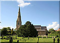
Holy Trinity Church
A Victorian church in Early English style with a fine broach spire; Pevsner describes it as "unimaginative Notts C13 style". It was built in 1844-46 to serve the expanding western end of the town. The Minster is the parish church of the town.
Image: © Alan Murray-Rust
Taken: 19 Jun 2008
0.04 miles
9
60-66 Westgate, Southwell
A row of three (originally four) early/mid 19th century cottages, Listed Grade II.
Image: © Alan Murray-Rust
Taken: 30 Aug 2020
0.04 miles
10
50 Westgate, Southwell ? Westby House
The pedimented range is the original house of the mid 18th century, the left hand range added in 1804 and the bay windows in the mid 19th; Listed Grade II, the Listing includes the garden wall.
Image: © Alan Murray-Rust
Taken: 30 Aug 2020
0.05 miles