IMAGES TAKEN NEAR TO
Willow Lane, SOUTHWELL, NG25 0FZ
Introduction
This page details the photographs taken nearby to Willow Lane, NG25 0FZ by members of the Geograph project.
The Geograph project started in 2005 with the aim of publishing, organising and preserving representative images for every square kilometre of Great Britain, Ireland and the Isle of Man.

There are currently over 7.5m images from over14,400 individuals and you can help contribute to the project by visiting https://www.geograph.org.uk
Image Map
Images are licensed for reuse under creativecommons.org/licenses/by-sa/2.0
Notes
- Clicking on the map will re-center to the selected point.
- The higher the marker number, the further away the image location is from the centre of the postcode.
Image Listing (37 Images Found)
Images are licensed for reuse under creativecommons.org/licenses/by-sa/2.0
Image
Details
Distance
1
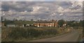
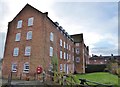
Maythorne
Looking down Maythorne Lane (carrying the Robin Hood Way) from its junction with the Southwell Trail. The mill hamlet at Maythorne has a total of seven listed buildings / structures, including the mill manager's house and cottages http://list.english-heritage.org.uk/resultsingle.aspx?uid=1369905&searchtype=mapsearch , prominent here, and the South Mill, a former spinning mill http://list.english-heritage.org.uk/resultsingle.aspx?uid=1289444&searchtype=mapsearch , which is the tall building just to its right. The complex is on the River Greet.
Image: © Derek Harper
Taken: Unknown
0.03 miles
2
Maythorne near Southwell
Seen from the Southwell Trail, Maythorne is a hamlet comprising a former silk mill and associated buildings and cottages.
Image: © Oliver Dixon
Taken: 7 Mar 2014
0.04 miles
3
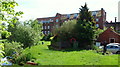
Maythorne, Southwell, Notts.
The mill pond and recreational area at the rear of the former yarn and thread mill. In additional to the individuals who now live in the cottages and apartments in this hamlet, the River Greet and the surrounding countryside attract fishing enthusiasts and walkers too.
Image: © David Hallam-Jones
Taken: 25 May 2013
0.04 miles
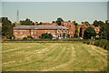
4
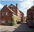
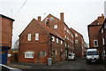
Maythorne, Southwell, Notts.
The former Maythorne Mill, its former workers’ cottages and its ancillary buildings, plus a farm, form the greater part of this small hamlet. It was a cotton mill built in 1785 to supply the framework knitting industry with yarns. The speculator that built Maythorne was a Southwell hop merchant. In the early C19th the mill was adapted to produce silk and lace thread by Messrs. Bean and Johnson and in 1838 the mill employed 70 workers, some of whom travelled in from Southwell. There was also a Mission Hall, a pub and general store. The workforce was mainly female who were required to wind silk on bobbins, form it into shanks before it was finally washed and pressed and despatched to Nottingham. However, yarn and thread products were not the only items produced here as osier beds provided willow for basket-making and hops were also grown locally. From 1939-45 the mill was used to billet soldiers and in 1948 H.J. Butler bought it and put the land and buildings to agricultural use. A Mr Butler still farms at the only farm in the hamlet and the mill building has been converted into residential flats and some workshops in various outbuildings. The mill wheel was powered by the River Greet and the mill pond and river can still be seen at the end of this cul-de-sac.
Image: © David Hallam-Jones
Taken: 24 May 2013
0.05 miles
5
Maythorne Mill
A cotton mill dating back to 1785, more recently a silk mill, converted to housing in the 1980s.
Image: © Chris Morgan
Taken: 19 Jan 2015
0.05 miles
6
Maythorne Mill
Maythorne Mill is a former cotton (and later silk) mill built in 1785. It was converted to housing in the 1980s.
Image: © Graham Hogg
Taken: 19 Jan 2015
0.05 miles
7
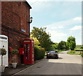
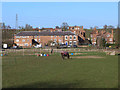
Maythorne, Southwell, Notts.
A former worker's cottage at the entrance (or exit) to the former mill hamlet of Maythorne. This is Maythorne Lane and the walkers in the distance may be heading for a nearby access point onto the Southwell Trail, i.e. the trail that follows the railway track bed along the former train route between Farnsfield and Rolleston Junction. Maythorne Lane is a cul-de-sac with the River Greet behind the photographer and Lower Kirklington Road 5 minutes away in the distance.
Image: © David Hallam-Jones
Taken: 25 May 2013
0.05 miles
8
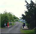
Maythorne, Southwell, Notts.
At the end of Maythorne Lane and within yards of the entrance to this hamlet is the entrance to a Camping and Caravanning Club site.
Image: © David Hallam-Jones
Taken: 25 May 2013
0.05 miles
9
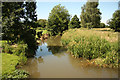
River Greet
Upstream from mill bridge and sluice http://www.geograph.org.uk/photo/3057553 at Maythorne
Image: © Richard Croft
Taken: 24 Jul 2012
0.06 miles
10
Maythorne
View from the Southwell Trail http://www.nottinghamshire.gov.uk/enjoying/countryside/nature-reserves/southwell-trail/ to the hamlet of Maythorne http://79.170.40.170/maythorne.org/?page_id=41 originally a mill complex with workers houses, now a residential community
Image: © Richard Croft
Taken: 24 Jul 2012
0.06 miles