IMAGES TAKEN NEAR TO
Woodland View, SOUTHWELL, NG25 0AG
Introduction
This page details the photographs taken nearby to Woodland View, NG25 0AG by members of the Geograph project.
The Geograph project started in 2005 with the aim of publishing, organising and preserving representative images for every square kilometre of Great Britain, Ireland and the Isle of Man.

There are currently over 7.5m images from over14,400 individuals and you can help contribute to the project by visiting https://www.geograph.org.uk
Image Map
Images are licensed for reuse under creativecommons.org/licenses/by-sa/2.0
Notes
- Clicking on the map will re-center to the selected point.
- The higher the marker number, the further away the image location is from the centre of the postcode.
Image Listing (45 Images Found)
Images are licensed for reuse under creativecommons.org/licenses/by-sa/2.0
Image
Details
Distance
3
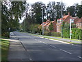
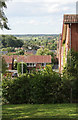
Southwell NG25, Notts.
The new-ish (c.2008) Merryweather Estate, off the Southwell-Halam road. This was a former location of the H. Merryweather & Sons Nursery and it was here that the famous Bramley apple was first cultivated. This is the Humberstone Road turning. The village of Halam lies in the distance, further westwards.
Image: © David Hallam-Jones
Taken: 25 May 2013
0.07 miles
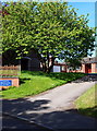
4
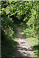
Woodland walk
In practice this footpath divides two areas of housing development on the hill to the west of Southwell town centre. This appears to be a boundary between different landowners, judged by the way development has taken place on either side of the footpath.
Image: © Alan Murray-Rust
Taken: 19 Jun 2008
0.09 miles
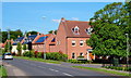
5
May Hill
Part of a new development on the north side of the hill labelled High Town on the 1:25000. View northward towards Sherwood Forest.
Image: © Alan Murray-Rust
Taken: 19 Jun 2008
0.09 miles
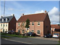
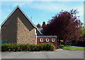
6

Humberstone Road
Small, modern housing estate off Halam Road, Southwell.
Image: © Ajay Tegala
Taken: 10 Dec 2008
0.09 miles
7
Southwell NG25, Notts.
The top car park of "Our Lady of Victories" Roman Catholic Church, Wolsey Close, off Halam Road. The church's name is a dedication to the Blessed Virgin Mary that also commemorates the Battle at Lepanto. This battle took place on 7 October 1571 when a fleet of the Holy League, a coalition of southern European Catholic maritime states, decisively defeated the main fleet of the Ottoman Empire in five hours of fighting on the northern edge of the Gulf of Corinth, off western Greece. The Ottoman forces sailing westwards from their naval station in Lepanto met the Holy League forces that had come from Messina. This victory curtailed the spread of the Ottoman Empire in this area. Lepanto was the last major naval battle in the Mediterranean to be fought entirely between galleys and has obviously been assigned great symbolic importance.
Image: © David Hallam-Jones
Taken: 25 May 2013
0.09 miles
8
Southwell NG25, Notts.
The driveway to the presbytery of "Our Lady of Victories" Roman Catholic Church, Wolsey Close, off Halam Road. The church's name is a dedication to the Blessed Virgin Mary and also commemorates the Battle of Lepanto. Halam Road, a "C" road linking Southwell and Halam, lies to the right.
Image: © David Hallam-Jones
Taken: 25 May 2013
0.11 miles
9
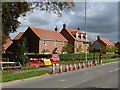
The end of Hopkiln Lane, Southwell
Closed during flood alleviation scheme works. The housing is early 21st century new development.
Image: © Alan Murray-Rust
Taken: 6 Sep 2020
0.12 miles
10
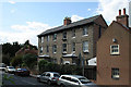
Norwood Villas
This building with its fake-stone stucco is completely out of place in the townscape. Its looks are not helped by the wide eaves which are not matched at the back, and the incongruity between the stucco and the plain brickwork of the end wall.
Image: © Alan Murray-Rust
Taken: 19 Jun 2008
0.13 miles