IMAGES TAKEN NEAR TO
Anderton Street, NOTTINGHAM, NG2 4RP
Introduction
This page details the photographs taken nearby to Anderton Street, NG2 4RP by members of the Geograph project.
The Geograph project started in 2005 with the aim of publishing, organising and preserving representative images for every square kilometre of Great Britain, Ireland and the Isle of Man.

There are currently over 7.5m images from over14,400 individuals and you can help contribute to the project by visiting https://www.geograph.org.uk
Image Map
Images are licensed for reuse under creativecommons.org/licenses/by-sa/2.0
Notes
- Clicking on the map will re-center to the selected point.
- The higher the marker number, the further away the image location is from the centre of the postcode.
Image Listing (106 Images Found)
Images are licensed for reuse under creativecommons.org/licenses/by-sa/2.0
Image
Details
Distance
1
Trent Lane: Trent Villa
The house is being used as a site office by Willmott Dixon, the contractors building riverside houses at Trent Basin. Green's Windmill is on the skyline on the right, above the silver car.
Image: © John Sutton
Taken: 16 May 2016
0.07 miles
2
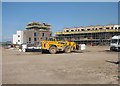
Trent Basin: big machinery
New homes are being built on the site of long-derelict riverside warehouses - "Connecting city life and waterside living", according to the publicity.
Image: © John Sutton
Taken: 16 May 2016
0.08 miles
3

Pleasure boats on the river
These three pleasure boats ply their trade up and down the River Trent between Wilford Image and Stoke Bardolf Image
Image: © Kate Jewell
Taken: 1 May 2008
0.08 miles
4

The exit of the Beck Valley Storm Water Culvert
The culvert is a major construction built in the 1880s to cope with surface water from the rapid urbanisation of the east side of Nottingham. It originates with the 'Beck' which flowed from St Ann's Well roughly on the line of St Ann's Well Road, Huntingdon Street and Lower Parliament Street to join the original River Leen a short distance east of the present London Road. To cope with the estimated maximum flow, based even then on a maximum recorded 1.4 inches (3.5 cm) in a 30 minute period, the culvert is 6 ft (1.8 m) diameter in its upper reaches, increasing to an oval cross section of 13ft 6 in x 9 ft 8 in (4.1 x 2.95 m).
Note the commemorative foundation stone facing out into the river, where it would be virtually unread. In practice this is double sided, with the same inscription on the inland face, seen here http://www.geograph.org.uk/photo/7041196
Image: © Alan Murray-Rust
Taken: 10 Dec 2021
0.08 miles
5
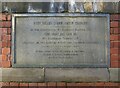
Beck Valley Storm Water Culvert foundation stone
The culvert is a major construction built in the 1880s to cope with surface water from the rapid urbanisation of the east side of Nottingham. It originates with the 'Beck' which flowed from St Ann's Well roughly on the line of St Ann's Well Road, Huntingdon Street and Lower Parliament Street to join the original River Leen a short distance east of the present London Road. To cope with the estimated maximum flow, based even then on a maximum recorded 1.4 inches (3.5 cm) in a 30 minute period, the culvert is 6 ft (1.8 m) diameter in its upper reaches, increasing to an oval cross section of 13ft 6 in x 9 ft 8 in (4.1 x 2.95 m).
The stone is double-sided and set in the wall at the end of Trent Lane above the exit of the culvert http://www.geograph.org.uk/photo/7041192
Image: © Alan Murray-Rust
Taken: 10 Dec 2021
0.08 miles
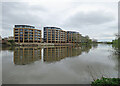
6
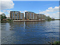
Yacht Club Riverside flats
Looking from the Bridgford side of the River Trent at Trent Field to the Yacht Club Riverside flats on the Sneinton side, which look externally complete. Image] shows building work in September 2021.
Image: © John Sutton
Taken: 15 Apr 2022
0.08 miles
7
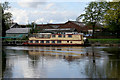
The Trent Lady
The Trent Lady was built by Arcrite of Corby Northamptonshire in 1984. The boat was registered in London and serviced the Thames. In 1992 the boat was purchased by Trent Cruising Ltd who had her hauled out of the water at Penton Marine Chertsey in Surrey, and transported by road to Newark Marina where it underwent a complete re-fit before entering into service on the Trent. In 2001 the boat was sold to the present operators, Trent River Cruises. The Trent lady is 68ft in length and weighs just over 33 tonnes.
See http://www.trentcruising.com/
Image: © Kate Jewell
Taken: 1 May 2008
0.08 miles
8

Trent-side warehouse
Disused warehouse across the Trent from the Trent Valley Way
Image: © Richard Croft
Taken: 15 Jul 2011
0.09 miles
9
Yacht Club Riverside
This development on the left bank of the Trent looks nearer completion than when I came this way in April 2022: see Image], which links to earlier views of the project.
Image: © John Sutton
Taken: 16 Apr 2023
0.09 miles
10

A May morning by the Trent
Pleasure boats are moored upstream of the River Crescent flats on the Sneinton side of the river.
Image: © John Sutton
Taken: 16 May 2016
0.09 miles