IMAGES TAKEN NEAR TO
Henry Street, NOTTINGHAM, NG2 4QT
Introduction
This page details the photographs taken nearby to Henry Street, NG2 4QT by members of the Geograph project.
The Geograph project started in 2005 with the aim of publishing, organising and preserving representative images for every square kilometre of Great Britain, Ireland and the Isle of Man.

There are currently over 7.5m images from over14,400 individuals and you can help contribute to the project by visiting https://www.geograph.org.uk
Image Map
Images are licensed for reuse under creativecommons.org/licenses/by-sa/2.0
Notes
- Clicking on the map will re-center to the selected point.
- The higher the marker number, the further away the image location is from the centre of the postcode.
Image Listing (307 Images Found)
Images are licensed for reuse under creativecommons.org/licenses/by-sa/2.0
Image
Details
Distance
1
Nottingham - NG3 (Sneinton)
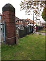
This gate post at the edge of King Edward Park, off Dakeyne Street, is all that remains of The General Lunatic Asylum for the Town & County of Nottingham. In 1873, once all its private patients had been transferred to The Coppice Hospital, Mapperley it became known as The County Lunatic Asylum. This was in turn replaced by Saxondale Hospital that served residents of Notts from 1902-88. During the late 50s and the 60s at least part of the Sneinton buildings were used by the Dakeyn Street Lads' Club (later to become The Oliver Hind Boys Brigade).
Image: © David Hallam-Jones
Taken: 5 May 2012
0.07 miles
2
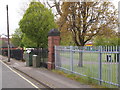
Nottingham - NG3 (Sneinton)
This gate post at the edge of King Edward Park off Dakeyne Street is all that remains of The General Lunatic Asylum for the Town & County of Nottingham. In 1873, once all its private patients had been transferred to The Coppice Hospital, Mapperley it became known as The County Lunatic Asylum. This was in turn replaced by Saxondale Hospital that served residents of Notts from 1902-88. During the late 50s and the 60s at least part of the Sneinton buildings were used by the Dakeyn Street Lads' Club (later to become The Oliver Hind Boys Brigade).
Image: © David Hallam-Jones
Taken: 5 May 2012
0.07 miles
3
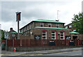
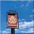
The Wheatsheaf, Sneinton Road, Nottingham
Estate pub built in 1964 by C. Howitt & Partners.
Image: © Stephen Richards
Taken: 19 Jun 2015
0.08 miles
5
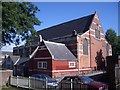
St. Alban's Church, Bond Street, Sneinton
By George Frederick Bodley
Image: © Andrew Abbott
Taken: 21 Jun 2008
0.08 miles
7
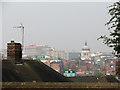
View from Windmill Lane
Looking across to Nottingham City Centre. The dome of the Council House can be seen to the left of the picture.
Image: © Alan Murray-Rust
Taken: 11 Feb 2007
0.09 miles
8
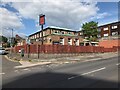
Sneinton Primary School, Windmill Lane
The small figure is a bollard to prevent parking on the footway!
Image: © Alan Murray-Rust
Taken: 11 Feb 2007
0.09 miles
9
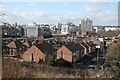
Sneinton view - 1
A foreshortened zoom view from Windmill Lane, over the rooftops of Walker Street, towards the Council House and the unpleasant high-rise blocks of Maid Marian Way.
Image: © John Sutton
Taken: 15 Apr 2011
0.09 miles
10
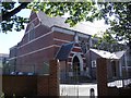
St. Alban's Church, Bond Street, Sneinton
By George Frederick Bodley.
Image: © Andrew Abbott
Taken: 21 Jun 2008
0.09 miles