IMAGES TAKEN NEAR TO
Victoria Terrace, NOTTINGHAM, NG2 4QP
Introduction
This page details the photographs taken nearby to Victoria Terrace, NG2 4QP by members of the Geograph project.
The Geograph project started in 2005 with the aim of publishing, organising and preserving representative images for every square kilometre of Great Britain, Ireland and the Isle of Man.

There are currently over 7.5m images from over14,400 individuals and you can help contribute to the project by visiting https://www.geograph.org.uk
Image Map
Images are licensed for reuse under creativecommons.org/licenses/by-sa/2.0
Notes
- Clicking on the map will re-center to the selected point.
- The higher the marker number, the further away the image location is from the centre of the postcode.
Image Listing (247 Images Found)
Images are licensed for reuse under creativecommons.org/licenses/by-sa/2.0
Image
Details
Distance
1
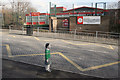
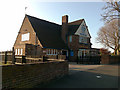
Sneinton Primary School, Windmill Lane
The small figure is a bollard to prevent parking on the footway!
Image: © Alan Murray-Rust
Taken: 11 Feb 2007
0.05 miles
2
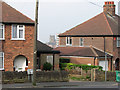
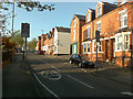
Sneinton: view from the corner of Walker Street
Windmill Lane climbs up the marlstone hills which form the hilly eastern side of the city. St Mary's Church in The Lace Market, seen between the houses on the corner of Walker Street, is on the lower sandstone bluff above the former course of the River Leen on which the original Saxon burgh developed.
Image: © John Sutton
Taken: 15 Apr 2011
0.05 miles
3
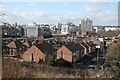
View from Windmill Lane
Looking across to Nottingham City Centre. The dome of the Council House can be seen to the left of the picture.
Image: © Alan Murray-Rust
Taken: 11 Feb 2007
0.06 miles
4
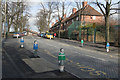
Windmill Lane at Sneinton Primary School.
Colourful figurines are bollards to deter motorists parking on the footway when collecting children. Most of them have a name written in felt pen on their foreheads. The two nearest are Sarah and Jack!
Image: © Alan Murray-Rust
Taken: 11 Feb 2007
0.06 miles
6
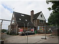
The Queen Adelaide
Closed since the last time I was here Image
Image: © David Lally
Taken: 25 Apr 2017
0.08 miles
7
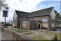
The former Queen Alexandra pub
Now being converted into apartments.
Image: © Jonathan Thacker
Taken: 5 Jun 2018
0.08 miles
8
The Queen Adelaide
On Windmill Lane, Sneinton.
Almost certainly this was built as a Hardy Hansons (Kimberley's) http://en.wikipedia.org/wiki/Kimberley_Brewery pub.
Image: © David Lally
Taken: 19 Apr 2009
0.08 miles
9
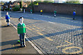
Child Bollards
Outside Sneinton Primary School. To deter pavement parking outside the school. They would certainly deter me!
This shot is the reverse view of Image by Alan Murray-Rust.
Image: © David Lally
Taken: 19 Apr 2009
0.08 miles
10
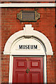
Number 12 Notintone Place
Birthplace of William Booth, fouder of the Salvation Army. Now a museum.
Image: © David Lally
Taken: 19 Apr 2009
0.08 miles