IMAGES TAKEN NEAR TO
Dale Street, NOTTINGHAM, NG2 4LE
Introduction
This page details the photographs taken nearby to Dale Street, NG2 4LE by members of the Geograph project.
The Geograph project started in 2005 with the aim of publishing, organising and preserving representative images for every square kilometre of Great Britain, Ireland and the Isle of Man.

There are currently over 7.5m images from over14,400 individuals and you can help contribute to the project by visiting https://www.geograph.org.uk
Image Map
Images are licensed for reuse under creativecommons.org/licenses/by-sa/2.0
Notes
- Clicking on the map will re-center to the selected point.
- The higher the marker number, the further away the image location is from the centre of the postcode.
Image Listing (245 Images Found)
Images are licensed for reuse under creativecommons.org/licenses/by-sa/2.0
Image
Details
Distance
1
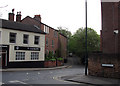
Sneinton: former frame-knitter's house
Windows like those on the third floor of the house opposite were once common in Nottingham. They were designed to throw as much light as possible on the frames in the workshops. In the late 18th and early 19th centuries, before the building of the huge tenement lace and hosiery factories which once characterised the city, most bobbin-net manufacture was done on this domestic scale. For other surviving examples, see Image] and Image
Image: © John Sutton
Taken: 15 Apr 2011
0.00 miles
2
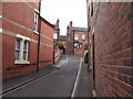
Nottingham - NG3 (Sneinton)
Perlethorpe Avenue is a very narrow street leading to up to (and into) the closed end of this intimate cul-de-sac obliquely opposite St Stephen's Anglican Church on Sneinton Road.
Image: © David Hallam-Jones
Taken: 7 May 2012
0.01 miles
3
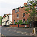
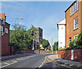
Sneinton: Dale Street and Belvoir Hill
The pleasing three-storey brick house on the corner of Belvoir Hill has large frameknitter's windows on the top floor and dates from the time when net and hosiery making were cottage industries. The large windows made the workshops light enough for fine work to be done for long hours in the years before gas and electric lighting. The house has outlived a lot of the Victorian tenement factories built to supersede it.
Image: © John Sutton
Taken: 15 Apr 2011
0.01 miles
4
Nottingham - NG3 (Sneinton)
The closed end of the Perlethorpe Avenue. Beyond the boundary wall is a small sloping field and a children's play area in the shadow of Green's Mill (windmill).
Image: © David Hallam-Jones
Taken: 7 May 2012
0.01 miles
5
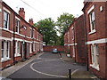
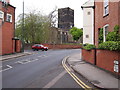
Sneinton: Dale Street
St Stephen's Church is on the crest of the hill. The house on the right, on the corner of Belvoir Hill, has a large frameknitter's window on the top floor and dates from the time when net and hosiery making was a cottage industry. It has outlived a lot of the Victorian tenement factories built to supersede it.
Image: © John Sutton
Taken: 4 Sep 2013
0.01 miles
6
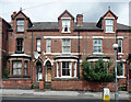
9-13 Dale Street, Nottingham
Picked out by Pevsner for demonstrating "Sneinton's distinctive 1890s tiled doorways and figurative hoodstops".
Image: © Stephen Richards
Taken: 19 Jun 2015
0.01 miles
7
Nottingham - NG3 (Sneinton)
The entrance/exit from Perlethorpe Avenue (a cul-de-sac) from and onto Dale Street, with nearby St Stephen's Anglican Church. The car is pulling out of Manor Road.
Image: © David Hallam-Jones
Taken: 7 May 2012
0.01 miles
8
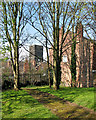
Sneinton: in Green's Mill Park
Looking towards St Stephen's Church on a sunny spring morning.
Image: © John Sutton
Taken: 13 Apr 2016
0.01 miles
9
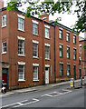
4-6 Dale Street, Nottingham
A pair of dignified early C19th houses with decorative lintels to the windows.
Image: © Stephen Richards
Taken: 19 Jun 2015
0.02 miles
10
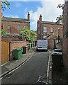
Sneinton: up Perlethorpe Avenue
Bins and backyards, photographed on a June morning.
Image: © John Sutton
Taken: 3 Jun 2017
0.02 miles