IMAGES TAKEN NEAR TO
Manor Street, NOTTINGHAM, NG2 4JP
Introduction
This page details the photographs taken nearby to Manor Street, NG2 4JP by members of the Geograph project.
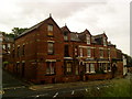
The Geograph project started in 2005 with the aim of publishing, organising and preserving representative images for every square kilometre of Great Britain, Ireland and the Isle of Man.

There are currently over 7.5m images from over14,400 individuals and you can help contribute to the project by visiting https://www.geograph.org.uk
Image Map
Images are licensed for reuse under creativecommons.org/licenses/by-sa/2.0
Notes
- Clicking on the map will re-center to the selected point.
- The higher the marker number, the further away the image location is from the centre of the postcode.
Image Listing (278 Images Found)
Images are licensed for reuse under creativecommons.org/licenses/by-sa/2.0
Image
Details
Distance
1
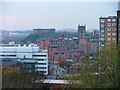
View West from Sneinton Windmill ...
... across the Lace Market towards Castle Rock. St. Mary's Church rises to the right.
Image: © Mick Garratt
Taken: 3 Dec 2005
0.02 miles
2
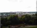
A view of the south of Nottingham, taken from the Green's Windmill
Image: © James Haynes
Taken: Unknown
0.02 miles
3
Sneinton: the corner of St Stephen's Avenue
Seen across St Stephen's Road on a sunny May morning.
Image: © John Sutton
Taken: 16 May 2016
0.02 miles
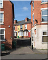
4
Sneinton: down St Stephen's Road
Sneinton expanded in the last twenty years of the nineteenth century. The gothic-arched paired doorways hereabouts all have male and female label stops: see Image] and Image
Image: © John Sutton
Taken: 16 May 2016
0.02 miles
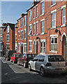
5
Sneinton: St Stephen's Avenue
Sneinton mushroomed after the parish became part of the Borough of Nottingham in 1877.
Image: © John Sutton
Taken: 16 May 2016
0.03 miles
6
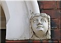
Sneinton: female label stop
The paired doorways of the three-storey terraced houses on St Stephen's Road have male and female heads at the bases of the arch mouldings - see Image For the wider context, see Image] and Image
Image: © John Sutton
Taken: 16 May 2016
0.03 miles
7
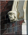
Sneinton: male label stop
The paired doorways of the three-storey terraced houses on St Stephen's Road have male and female heads at the bases of the arch mouldings - see Image For the wider context, see Image] and Image
Image: © John Sutton
Taken: 16 May 2016
0.03 miles
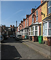
8
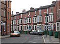
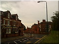
Sneinton: Lees Hill Street
Typical three-storey terraced houses built in the years after Sneinton became part of the Borough of Nottingham in 1877. Houses like this can be found all over the city in the inner suburbs which mushroomed in the last quarter of the 19th century.
Image: © John Sutton
Taken: 15 Apr 2011
0.04 miles