IMAGES TAKEN NEAR TO
Lord Nelson Street, NOTTINGHAM, NG2 4FA
Introduction
This page details the photographs taken nearby to Lord Nelson Street, NG2 4FA by members of the Geograph project.
The Geograph project started in 2005 with the aim of publishing, organising and preserving representative images for every square kilometre of Great Britain, Ireland and the Isle of Man.

There are currently over 7.5m images from over14,400 individuals and you can help contribute to the project by visiting https://www.geograph.org.uk
Image Map
Images are licensed for reuse under creativecommons.org/licenses/by-sa/2.0
Notes
- Clicking on the map will re-center to the selected point.
- The higher the marker number, the further away the image location is from the centre of the postcode.
Image Listing (235 Images Found)
Images are licensed for reuse under creativecommons.org/licenses/by-sa/2.0
Image
Details
Distance
1
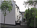
Sneinton: The Lord Nelson
This pantiled pub, at right angles the street which shares its name, is one of the few buildings in Sneinton which predates the expansion of the district in the last quarter of the nineteenth century.
Image: © John Sutton
Taken: 15 Apr 2011
0.01 miles
2
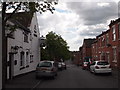
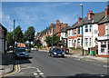
Nottingham - NG3 (Old Sneinton)
"The Lord Nelson" pub is housed in an early 18th century building at the Sneinton Dale end of Lord Nelson Street. This is quite a long road joining Thurgarton Street at its lower end.
Image: © David Hallam-Jones
Taken: 12 May 2012
0.02 miles
3
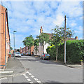
Sneinton: The Lord Nelson
A picture taken from the corner of Thurgarton Street (left) and Lord Nelson Street on a bright June morning.
Image: © John Sutton
Taken: 3 Jun 2017
0.02 miles
4
Sneinton: up Pullman Road
Houses built as the Borough expanded in the last twenty years of the nineteenth century, photographed on a bright spring morning.
Image: © John Sutton
Taken: 13 Apr 2016
0.03 miles
5
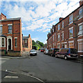
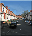
Sneinton: Thurgarton Street
Typical two- and three-storey terraced houses built in the last quarter of the nineteenth century, when Nottingham expanded rapidly. Pullman Road is to the left and Lord Nelson Street ahead. Like nearby Bleasby Street, Thurgarton Street takes its name from a village in the Trent Valley between Nottingham and Newark.
Image: © John Sutton
Taken: 3 Jun 2017
0.03 miles
6
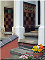
Sneinton: Victorian porches on Pullman Road
The terraced houses on Pullman Road retain their colourful Minton tiles and some original stone steps.
Image: © John Sutton
Taken: 13 Jun 2013
0.03 miles
7
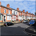
Sneinton: Pullman Road
Terraced villas built as the Borough expanded in the last twenty years of the nineteenth century. These have rather fancier porches than many similar houses in Nottingham.
Image: © John Sutton
Taken: 3 Jun 2017
0.03 miles
8
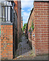
Sneinton: up the entry
Campanula growing in the wall of the passage behind houses on the south side of Sneinton Dale. The house on the left is the first one on Trent Road.
Image: © John Sutton
Taken: 3 Jun 2017
0.03 miles
9
Sneinton Dale
Looking towards the city from near the corner of Trent Road.
Image: © John Sutton
Taken: 4 Jul 2016
0.04 miles
10
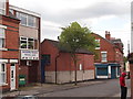
Nottingham - NG3 (Old Sneinton)
The Nottingham Building Trades Social Club on Thurgarton Street near to the junction with Lord Nelson Street.
Image: © David Hallam-Jones
Taken: 12 May 2012
0.04 miles