IMAGES TAKEN NEAR TO
Bendigo Lane, NOTTINGHAM, NG2 4EH
Introduction
This page details the photographs taken nearby to Bendigo Lane, NG2 4EH by members of the Geograph project.
The Geograph project started in 2005 with the aim of publishing, organising and preserving representative images for every square kilometre of Great Britain, Ireland and the Isle of Man.

There are currently over 7.5m images from over14,400 individuals and you can help contribute to the project by visiting https://www.geograph.org.uk
Image Map
Images are licensed for reuse under creativecommons.org/licenses/by-sa/2.0
Notes
- Clicking on the map will re-center to the selected point.
- The higher the marker number, the further away the image location is from the centre of the postcode.
Image Listing (84 Images Found)
Images are licensed for reuse under creativecommons.org/licenses/by-sa/2.0
Image
Details
Distance
2
Daleside Road
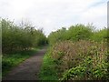
This is a very dull photograph of interest only to railway enthusiasts. Behind the camera Daleside Road East, the A612 to Southwell, is a road built on the course of an abandoned section of the Great Northern Railway line to Grantham. The bushes straight ahead are growing on the part of the trackbed which is now a footpath (see Image], Image] and others).
Image: © John Sutton
Taken: 20 Apr 2012
0.08 miles
3
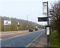
Colwick Road bus terminus
Until the late 1970s, City Transport buses terminated at this point, which had been the City boundary. The turnround was built when trolleybuses replaced the trams, which had also run to this point, in the mid 1930s.
Beyond this point services were provided by the Trent Motor Traction Company (today's Trent-Barton), but they were not allowed to carry local passengers inside the City area. Changes in regulations, followed by complete deregulation, meant a complete restructuring of services and a terminus at this location became superfluous. It has not now been used for more than 20 years.
Image: © Alan Murray-Rust
Taken: 20 Jun 2008
0.08 miles
4
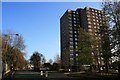
Colwick Road and Colwick Woods Court
Just the other side of the trees in the centre of the picture is the old bus terminus described here Image
Image: © David Lally
Taken: 30 Nov 2009
0.09 miles
5
Path on a former railway embankment
After the closure of Nottingham Victoria Station in 1966 the parts of the Great Northern Railway Grantham line through Sneinton to Netherfield were abandoned. Since then, Grantham trains have used the Midland route as far as Netherfield, where the Lincoln and Grantham lines part. The GNR trackbed is now a footpath from through Sneinton from Manvers Street to Daleside Road East. This is a view towards Nottingham, with the incinerator chimney just visible in the distance above the path.
Image: © John Sutton
Taken: 20 Apr 2012
0.09 miles
6
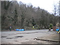
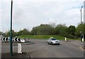
Colwick Road turning circle, Sneinton
This turning circle was used initially by trolleybuses, and later by motorbuses, as the terminus of the Colwick Road route, which continued across Nottingham city centre to Bulwell Hall (with alternate journeys diverted to serve Rise Park when that estate was constructed). For many years now, the route serving Colwick Road has continued to Gedling via Netherfield, but this turning circle still sees use when the level crossing just out of frame to the right is closed and a shuttle bus is run to serve Colwick Road. Colwick Woods nature reserve provides the backdrop.
Image: © Richard Vince
Taken: 13 Apr 2013
0.09 miles
7
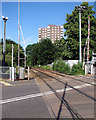
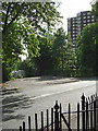
Colwick Road Level Crossing
Looking in the direction of Nottingham Station and the Colwick Woods Court tower block.
Image: © John Sutton
Taken: 4 Jul 2016
0.09 miles
8
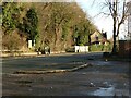
The old bus terminus loop, Colwick Crossing
The terminus initially of Corporation trams and later trolleybuses and motor buses at the City boundary, it ceased to be used when co-ordinated services between the Corporation and Trent Motor Traction were introduced in the early 1980s.
Image: © Alan Murray-Rust
Taken: 25 Dec 2020
0.09 miles
10

An eastbound train at Colwick Road Level Crossing
The Midland Railway Crossing Keeper's House is on the left, deeply shadowed on a sunny July morning. The picture was taken from the footpath which climbs through Colwick Woods.
Image: © John Sutton
Taken: 4 Jul 2016
0.10 miles