IMAGES TAKEN NEAR TO
Crabtree Field, NOTTINGHAM, NG2 4DY
Introduction
This page details the photographs taken nearby to Crabtree Field, NG2 4DY by members of the Geograph project.
The Geograph project started in 2005 with the aim of publishing, organising and preserving representative images for every square kilometre of Great Britain, Ireland and the Isle of Man.

There are currently over 7.5m images from over14,400 individuals and you can help contribute to the project by visiting https://www.geograph.org.uk
Image Map
Images are licensed for reuse under creativecommons.org/licenses/by-sa/2.0
Notes
- Clicking on the map will re-center to the selected point.
- The higher the marker number, the further away the image location is from the centre of the postcode.
Image Listing (72 Images Found)
Images are licensed for reuse under creativecommons.org/licenses/by-sa/2.0
Image
Details
Distance
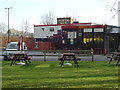
1
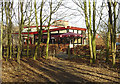
The Starting Gate
A public house on the edge of Colwick Country Park; it takes its name from the adjacent starting gate on Nottingham Racecourse.
Image: © Alan Murray-Rust
Taken: 6 Jan 2008
0.06 miles
5
The Starting Gate
A public house on the edge of Colwick Country Park; it takes its name from the adjacent starting gate on Nottingham Racecourse and was built at the same time as, and in similar style to, the adjacent Candle Meadow housing estate which can be seen at the back.
Image: © Alan Murray-Rust
Taken: 6 Jan 2008
0.07 miles
6
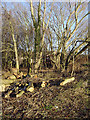
Felled timber in Colwick Country Park
Image: © Alan Murray-Rust
Taken: 6 Jan 2008
0.07 miles
7
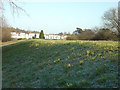
Flood bank at Colwick Country Park
The whiteboarded houses are part of the Candle Meadow estate.
Image: © Alan Murray-Rust
Taken: 6 Jan 2008
0.08 miles
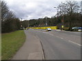
8
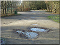
Car Park at Colwick Country Park
A clear sunny morning after a frosty night
Image: © Alan Murray-Rust
Taken: 6 Jan 2008
0.08 miles
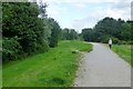
9
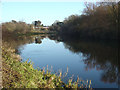
The old river
This peaceful pond is the last remnant of the old course of the River Trent and can be considered as a man-made ox-bow lake. The River was straightened when the new Holme Sluice was built.
Image: © Alan Murray-Rust
Taken: 6 Jan 2008
0.08 miles
10
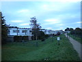
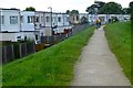
Northern end of Colwick Country Park
This footpath, along what appears to be a flood defence embankment, follows the northern perimeter of the country park alongside housing in Candle Meadow (left).
Image: © Richard Vince
Taken: 16 Nov 2013
0.08 miles