IMAGES TAKEN NEAR TO
Navigation Street, NOTTINGHAM, NG2 4DR
Introduction
This page details the photographs taken nearby to Navigation Street, NG2 4DR by members of the Geograph project.
The Geograph project started in 2005 with the aim of publishing, organising and preserving representative images for every square kilometre of Great Britain, Ireland and the Isle of Man.

There are currently over 7.5m images from over14,400 individuals and you can help contribute to the project by visiting https://www.geograph.org.uk
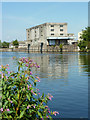
Image Map
Images are licensed for reuse under creativecommons.org/licenses/by-sa/2.0
Notes
- Clicking on the map will re-center to the selected point.
- The higher the marker number, the further away the image location is from the centre of the postcode.
Image Listing (102 Images Found)
Images are licensed for reuse under creativecommons.org/licenses/by-sa/2.0
Image
Details
Distance
1
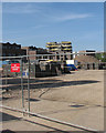
Trent Basin building site
A view through the Trent Lane fence. Homes are being built on the site of riverside warehouses which had been derelict for many years.
Image: © John Sutton
Taken: 16 May 2016
0.03 miles
2
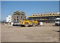
Trent Basin: big machinery
New homes are being built on the site of long-derelict riverside warehouses - "Connecting city life and waterside living", according to the publicity.
Image: © John Sutton
Taken: 16 May 2016
0.04 miles
4
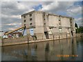
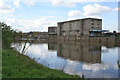
British Waterways warehouse by entrance to Trent Basin
An adjacent building, of equal ugliness, has the date '1930'. This area is destined to be completely 'regenerated', see http://www.trentbasin.co.uk/
Image: © Tim Heaton
Taken: 29 Jun 2008
0.04 miles
5
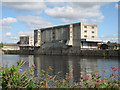
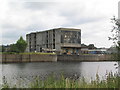
Nottingham Corporation Warehouse
Ownership is proclaimed in moulded letters along the roof parapet, with the building date, 1930, on each hoist. Along with the Cambridge Travelodge http://www.geograph.org.uk/photo/1778052 this must be a contender in any Ugliest Building in Britain contest....
Image: © John Sutton
Taken: 13 Aug 2009
0.05 miles
6
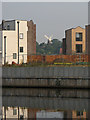
New housing and Green's Windmill
A telephoto shot across the Trent, with some of the as yet incomplete new homes at Trent Basin framing Green's Windmill in Sneinton. For a wider view, see Image
Image: © John Sutton
Taken: 8 Sep 2016
0.05 miles
7
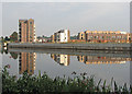
Trent Basin nearer completion
New homes on the site of riverside warehouses. St Stephen's Church and Green's Windmill in the centre of Sneinton show between the new blocks.
Earlier views:
Image] (August 2009)
Image] (May 2013)
Image] (April 2016)
Image] (May 2016)
Image: © John Sutton
Taken: 8 Sep 2016
0.05 miles
8
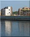
Housebuilding at Trent Basin
A May-morning zoom view across the river, with the new blocks framing Green's Windmill in the middle of Sneinton.
Image: © John Sutton
Taken: 16 May 2016
0.05 miles
9
Trent-side warehouse
Disused warehouse across the Trent from the Trent Valley Way
Image: © Richard Croft
Taken: 15 Jul 2011
0.05 miles
10
Old industrial building on the Trent
The River Trent waterside down stream from Trent Bridge in Nottingham was once a thriving industrial area. It has become a run down forgotten corner of the city with many of the old buildings lying empty. Luckily this whole area is part of a plan to reinvent Nottingham managed by Nottingham Redevelopment Limited which was set up in 1998. Taken from the Lady Bay bank of the river.
See their web site at http://www.nottinghamregeneration.ltd.uk/rightFoundations.html
Image: © Kate Jewell
Taken: 1 May 2008
0.05 miles