IMAGES TAKEN NEAR TO
Victoria Street, NEWARK, NG24 4UF
Introduction
This page details the photographs taken nearby to Victoria Street, NG24 4UF by members of the Geograph project.
The Geograph project started in 2005 with the aim of publishing, organising and preserving representative images for every square kilometre of Great Britain, Ireland and the Isle of Man.

There are currently over 7.5m images from over14,400 individuals and you can help contribute to the project by visiting https://www.geograph.org.uk
Image Map
Images are licensed for reuse under creativecommons.org/licenses/by-sa/2.0
Notes
- Clicking on the map will re-center to the selected point.
- The higher the marker number, the further away the image location is from the centre of the postcode.
Image Listing (291 Images Found)
Images are licensed for reuse under creativecommons.org/licenses/by-sa/2.0
Image
Details
Distance
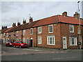
2
#84 Victoria Street
There is an OS benchmark Image on the wall behind the letter box post
Image: © Roger Templeman
Taken: 2 May 2016
0.01 miles
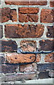
3
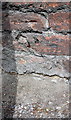
Benchmark on boundary wall of #84 Victoria Street
Ordnance Survey cut mark benchmark described on the Bench Mark Database at http://www.bench-marks.org.uk/bm75309
Image: © Roger Templeman
Taken: 2 May 2016
0.01 miles
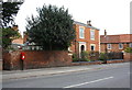
4

Brunswick House, Victoria Street, Newark
Dates from about 1790 https://historicengland.org.uk/listing/the-list/list-entry/1232092?section=official-list-entry
Image: © Jonathan Thacker
Taken: 13 Mar 2022
0.02 miles
5
72 and &4 Victoria Street, Newark
Date from about 1800 https://historicengland.org.uk/listing/the-list/map-search?clearresults=True
Image: © Jonathan Thacker
Taken: 13 Mar 2022
0.03 miles
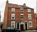
6
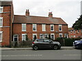
64-70 Victoria Street, Newark
Date from about 1800 https://historicengland.org.uk/listing/the-list/list-entry/1232088?section=official-list-entry
Image: © Jonathan Thacker
Taken: 13 Mar 2022
0.04 miles
7
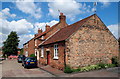
Newark, Notts (Mill Gate Area)
This single-storey building on King Street in the Mill Gate conservation area is a former school. It is now a private residence. (No other information available). Mill Gate lies beyond the striped barriers.
Image: © David Hallam-Jones
Taken: 21 Jul 2012
0.04 miles
8
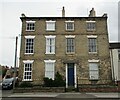
39 Victoria Street, Newark
Dates from about 1840 https://historicengland.org.uk/listing/the-list/list-entry/1232080?section=official-list-entry The yellow brick is unusual for Newark and given the date of the house may have been brought in by the Great Northern Railway (which, however, only opened in 1851). The blank windows on the left can be explained by there being another frontage on Prince's Street.
Image: © Jonathan Thacker
Taken: 13 Mar 2022
0.05 miles
9
Benchmark on #17 Parliament Street
Ordnance Survey cut mark benchmark described on the Bench Mark Database at http://www.bench-marks.org.uk/bm75308
Image: © Roger Templeman
Taken: 2 May 2016
0.05 miles
10
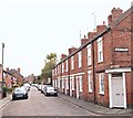
Parliament Street, Newark on Trent, Notts.
This street links Millgate - behind the photographer - and the B6166 (a.k.a. Victoria Street) 200 metres ahead. The town centre can be reached by taking a right turn on the B6166, whereas a left turn leads westwards towards Farndon and ultimately to Nottingham.
Image: © David Hallam-Jones
Taken: 29 Oct 2017
0.05 miles