IMAGES TAKEN NEAR TO
Fosse Road, NEWARK, NG24 4ST
Introduction
This page details the photographs taken nearby to Fosse Road, NG24 4ST by members of the Geograph project.
The Geograph project started in 2005 with the aim of publishing, organising and preserving representative images for every square kilometre of Great Britain, Ireland and the Isle of Man.

There are currently over 7.5m images from over14,400 individuals and you can help contribute to the project by visiting https://www.geograph.org.uk
Image Map
Images are licensed for reuse under creativecommons.org/licenses/by-sa/2.0
Notes
- Clicking on the map will re-center to the selected point.
- The higher the marker number, the further away the image location is from the centre of the postcode.
Image Listing (18 Images Found)
Images are licensed for reuse under creativecommons.org/licenses/by-sa/2.0
Image
Details
Distance
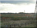
3
Long Lane
An old established lane giving access to riverside fields to the north of Farndon village, developed from the 1930s onwards as a suburban area of Newark.
Image: © Alan Murray-Rust
Taken: 27 Nov 2009
0.14 miles
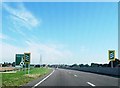
5
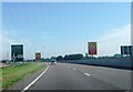
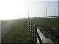
The new A46
The alignment of the new A46 on the approach to Farndon roundabout. Between Syerston and Farndon, the redeveloped road will run to the east of the traditional Fosse Way alignment.
Image: © Alan Murray-Rust
Taken: 27 Nov 2009
0.16 miles
8
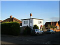
2a Linton Close, Farndon
Modernist house.
Image: © Jonathan Thacker
Taken: 1 Dec 2020
0.17 miles
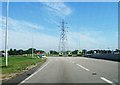
9
Fosse Road
Farm access to Farndon Fields adjacent to the newly-upgraded A46.
Image: © Burgess Von Thunen
Taken: 19 Feb 2013
0.17 miles
10
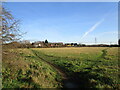
Grass field with unofficial paths
Looking towards Crees Lane and the A46 roundabout.
Image: © Jonathan Thacker
Taken: 1 Dec 2020
0.17 miles