IMAGES TAKEN NEAR TO
St. Catherines Close, NEWARK, NG24 4QD
Introduction
This page details the photographs taken nearby to St. Catherines Close, NG24 4QD by members of the Geograph project.
The Geograph project started in 2005 with the aim of publishing, organising and preserving representative images for every square kilometre of Great Britain, Ireland and the Isle of Man.

There are currently over 7.5m images from over14,400 individuals and you can help contribute to the project by visiting https://www.geograph.org.uk
Image Map
Images are licensed for reuse under creativecommons.org/licenses/by-sa/2.0
Notes
- Clicking on the map will re-center to the selected point.
- The higher the marker number, the further away the image location is from the centre of the postcode.
Image Listing (90 Images Found)
Images are licensed for reuse under creativecommons.org/licenses/by-sa/2.0
Image
Details
Distance
2
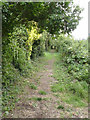
Line of tramroad, Sconce Hills
This track through allotment gardens is the line of the former tramroad from Hawton Gypsum Works http://www.geograph.org.uk/photo/3138273 . Most of the line of the tramway has been obliterated by the development of Hawtonville housing.
Image: © Alan Murray-Rust
Taken: 14 Sep 2012
0.08 miles
3
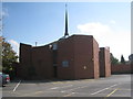
Holy Trinity Roman Catholic Church
Completed in 1979.
Image: © Jonathan Thacker
Taken: 24 Sep 2011
0.10 miles
4
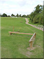
Exercise equipment, Sconce Hills Park
A series of exercises incorporated as part of recent refurbishment of the Sconce and the park.
Image: © Alan Murray-Rust
Taken: 14 Sep 2012
0.10 miles
5
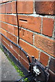
Benchmark on #4 Windsor Avenue
Ordnance Survey cut mark benchmark described on the Bench Mark Database at http://www.bench-marks.org.uk/bm75301
Image: © Roger Templeman
Taken: 2 May 2016
0.11 miles
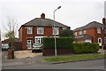
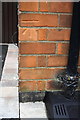
7
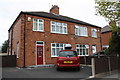
Nos. 52 and 50 Windsor Avenue
There is an OS benchmark Image on the front of the left hand house between the black downpipe and the left hand corner
Image: © Roger Templeman
Taken: 2 May 2016
0.12 miles
8
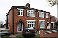
Nos 2 and 4 Windsor Avenue
There is an OS benchmark Image on the side of the left hand house near the front corner beside the grey car
Image: © Roger Templeman
Taken: 2 May 2016
0.12 miles
9
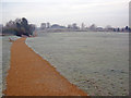
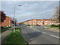
Sconce and Devon Park
Looking south-west along the new perimeter path on a very frosty January morning. The earthwork of the Queen's Sconce is on the far side of this field. The River Devon forms the western boundary of the park, providing the other part of the park name. The sconce is one of the best-preserved earthwork fortifications in Britain. Built in 1644, it played a prominent role in the Royalist defences during the Third Siege of Newark by Parliamentary forces.
http://www.newark-sherwooddc.gov.uk/sconceanddevon/
Image: © Trevor Rickard
Taken: 29 Jan 2012
0.12 miles
10
Benchmark on #52 Windsor Avenue
Ordnance Survey cut mark benchmark described on the Bench Mark Database at http://www.bench-marks.org.uk/bm75302
Image: © Roger Templeman
Taken: 2 May 2016
0.12 miles