IMAGES TAKEN NEAR TO
Grange Road, NEWARK, NG24 4LG
Introduction
This page details the photographs taken nearby to Grange Road, NG24 4LG by members of the Geograph project.
The Geograph project started in 2005 with the aim of publishing, organising and preserving representative images for every square kilometre of Great Britain, Ireland and the Isle of Man.

There are currently over 7.5m images from over14,400 individuals and you can help contribute to the project by visiting https://www.geograph.org.uk
Image Map
Images are licensed for reuse under creativecommons.org/licenses/by-sa/2.0
Notes
- Clicking on the map will re-center to the selected point.
- The higher the marker number, the further away the image location is from the centre of the postcode.
Image Listing (31 Images Found)
Images are licensed for reuse under creativecommons.org/licenses/by-sa/2.0
Image
Details
Distance
1
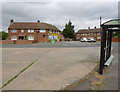
Grange Road bus turn round
Clearly built as a turn round, it is now simply a through stop in the current route pattern.
Image: © Alan Murray-Rust
Taken: 4 Sep 2012
0.02 miles
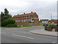
2
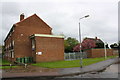
Standish House and outbuilding by bus stop
There is an OS benchmark Image on the outbuilding behind the bus stop
Image: © Roger Templeman
Taken: 2 May 2016
0.02 miles
3
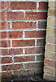
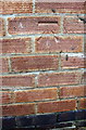
Benchmark on outbuilding of Standish House
Ordnance Survey cut mark benchmark described on the Bench Mark Database at http://www.bench-marks.org.uk/bm75319
Image: © Roger Templeman
Taken: 2 May 2016
0.02 miles
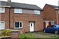
5
Gill House, Grange Road
One of a pair of maisonette blocks at the south-eastern corner of Hawtonville.
Image: © Alan Murray-Rust
Taken: 4 Sep 2012
0.03 miles
6
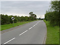
Bowbridge Lane
Bowbridge Road becomes Bowbridge Lane at the end of the built up area but retains its main road characteristics.
Image: © Alan Murray-Rust
Taken: 4 Sep 2012
0.06 miles
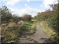
7
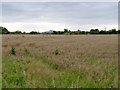
Cornfield off Bowbridge Road
Looking towards the plaster factory in the distance.
Image: © Alan Murray-Rust
Taken: 4 Sep 2012
0.08 miles
8
#47 Trinity Road
There is an OS benchmark Image on the front of the house at its right hand corner (by the blue car)
Image: © Roger Templeman
Taken: 2 May 2016
0.08 miles
9
Benchmark on #47 Trinity Road
Ordnance Survey cut mark benchmark described on the Bench Mark Database at http://www.bench-marks.org.uk/bm75320
Image: © Roger Templeman
Taken: 2 May 2016
0.08 miles
10
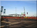
Christ Church Primary School under construction
The new school is due to open in September 2021.
Image: © Jonathan Thacker
Taken: 1 Dec 2020
0.12 miles